You are here: Home > Network List > BK - Berkeley Digital Seismograph Network Stations List
> Station WDC Whiskeytown, CA > Earthquake Result Viewer
WDC Whiskeytown, CA - Earthquake Result Viewer
| Earthquake location: |
Kermadec Islands Region |
| Earthquake latitude/longitude: |
-30.6/-179.7 |
| Earthquake time(UTC): |
2013/08/12 (224) 04:16:47 GMT |
| Earthquake Depth: |
341 km |
| Earthquake Magnitude: |
6.1 MWW, 6.1 MWC, 6.2 MWC, 6.2 MWB |
| Earthquake Catalog/Contributor: |
NEIC PDE/NEIC COMCAT |
|
| Network: |
BK Berkeley Digital Seismograph Network |
| Station: |
WDC Whiskeytown, CA |
| Lat/Lon: |
40.58 N/122.54 W |
| Elevation: |
268 m |
|
| Distance: |
88.4 deg |
| Az: |
39.793 deg |
| Baz: |
226.412 deg |
| Ray Param: |
0.041765533 |
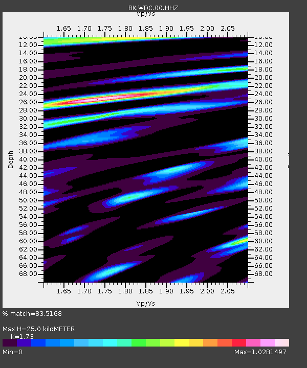
| Estimated Moho Depth: |
25.0 km |
| Estimated Crust Vp/Vs: |
1.73 |
| Assumed Crust Vp: |
6.566 km/s |
| Estimated Crust Vs: |
3.795 km/s |
| Estimated Crust Poisson's Ratio: |
0.25 |
|
| Radial Match: |
83.5168 % |
| Radial Bump: |
400 |
| Transverse Match: |
78.91207 % |
| Transverse Bump: |
400 |
| SOD ConfigId: |
626651 |
| Insert Time: |
2014-04-17 21:47:07.261 +0000 |
| GWidth: |
2.5 |
| Max Bumps: |
400 |
| Tol: |
0.001 |
|

Signal To Noise
| Channel | StoN | STA | LTA |
| BK:WDC:00:HHZ:20130812T04:28:30.588025Z | 30.524464 | 1.1682163E-6 | 3.8271473E-8 |
| BK:WDC:00:HHN:20130812T04:28:30.588025Z | 4.9381256 | 2.0699198E-7 | 4.191712E-8 |
| BK:WDC:00:HHE:20130812T04:28:30.588025Z | 1.6135904 | 7.2616814E-8 | 4.500325E-8 |
| Arrivals |
| Ps | 2.8 SECOND |
| PpPs | 10 SECOND |
| PsPs/PpSs | 13 SECOND |


