You are here: Home > Network List > IU - Global Seismograph Network (GSN - IRIS/USGS) Stations List
> Station POHA Pohakuloa, Hawaii, USA > Earthquake Result Viewer
POHA Pohakuloa, Hawaii, USA - Earthquake Result Viewer
*The percent match for this event was below the threshold and hence no stack was calculated.
| Earthquake location: |
Kermadec Islands Region |
| Earthquake latitude/longitude: |
-30.6/-179.7 |
| Earthquake time(UTC): |
2013/08/12 (224) 04:16:47 GMT |
| Earthquake Depth: |
341 km |
| Earthquake Magnitude: |
6.1 MWW, 6.1 MWC, 6.2 MWC, 6.2 MWB |
| Earthquake Catalog/Contributor: |
NEIC PDE/NEIC COMCAT |
|
| Network: |
IU Global Seismograph Network (GSN - IRIS/USGS) |
| Station: |
POHA Pohakuloa, Hawaii, USA |
| Lat/Lon: |
19.76 N/155.53 W |
| Elevation: |
1990 m |
|
| Distance: |
55.2 deg |
| Az: |
27.975 deg |
| Baz: |
205.424 deg |
| Ray Param: |
$rayparam |
*The percent match for this event was below the threshold and hence was not used in the summary stack. |
|
| Radial Match: |
53.68924 % |
| Radial Bump: |
400 |
| Transverse Match: |
49.913437 % |
| Transverse Bump: |
400 |
| SOD ConfigId: |
626651 |
| Insert Time: |
2014-04-17 21:53:41.570 +0000 |
| GWidth: |
2.5 |
| Max Bumps: |
400 |
| Tol: |
0.001 |
|
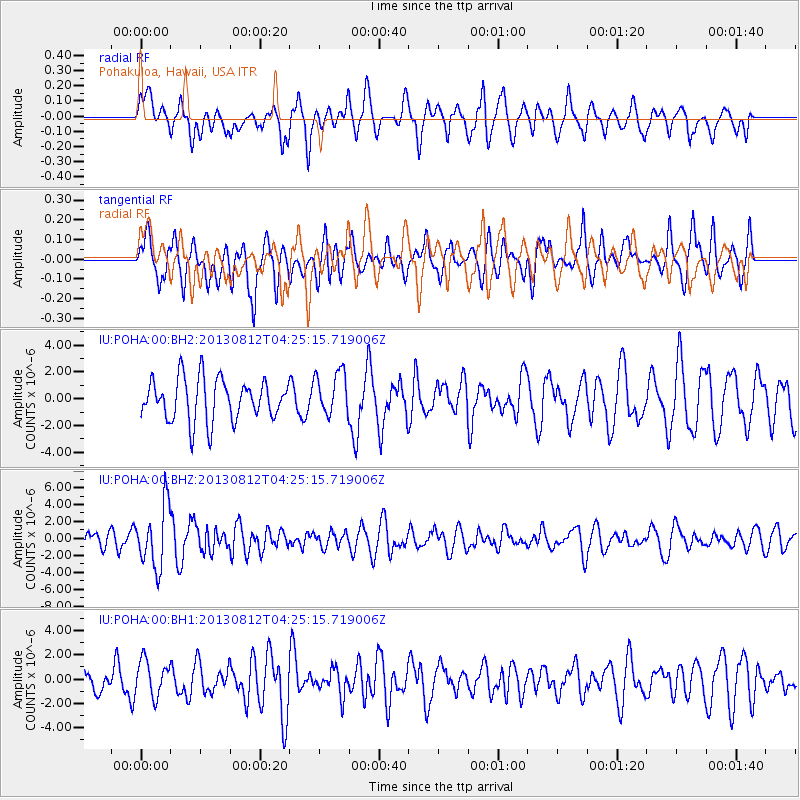
Signal To Noise
| Channel | StoN | STA | LTA |
| IU:POHA:00:BHZ:20130812T04:25:15.719006Z | 2.7429476 | 3.6714046E-6 | 1.3384888E-6 |
| IU:POHA:00:BH1:20130812T04:25:15.719006Z | 0.801242 | 1.4943997E-6 | 1.8651042E-6 |
| IU:POHA:00:BH2:20130812T04:25:15.719006Z | 1.0565728 | 1.6436944E-6 | 1.555685E-6 |
| Arrivals |
| Ps | |
| PpPs | |
| PsPs/PpSs | |


