You are here: Home > Network List > TA - USArray Transportable Network (new EarthScope stations) Stations List
> Station G05D Wamic, OR, USA > Earthquake Result Viewer
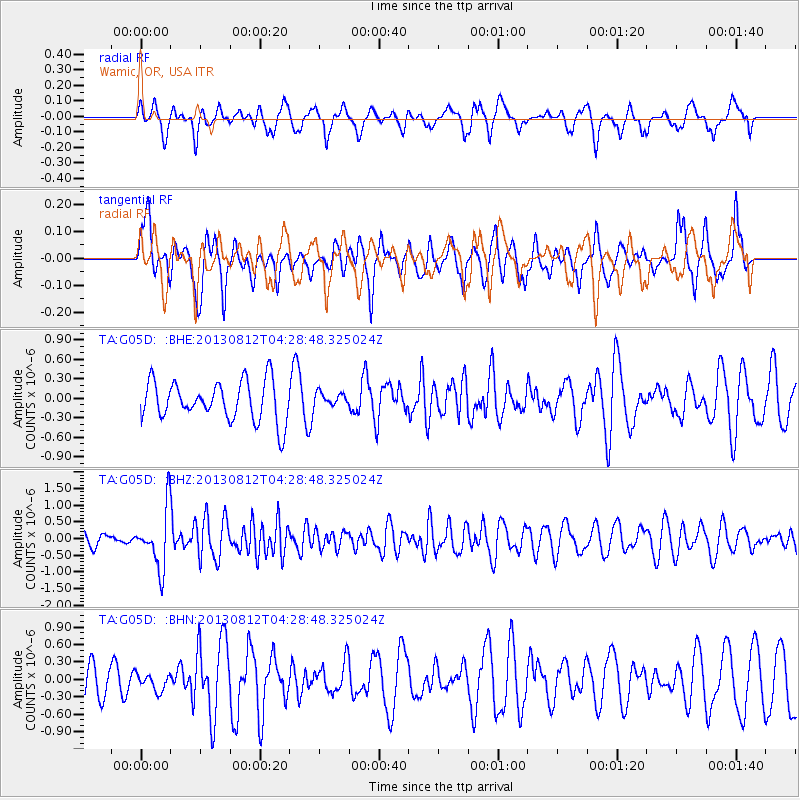
G05D Wamic, OR, USA - Earthquake Result Viewer
*The percent match for this event was below the threshold and hence no stack was calculated.
| Earthquake location: |
Kermadec Islands Region |
| Earthquake latitude/longitude: |
-30.6/-179.7 |
| Earthquake time(UTC): |
2013/08/12 (224) 04:16:47 GMT |
| Earthquake Depth: |
341 km |
| Earthquake Magnitude: |
6.1 MWW, 6.1 MWC, 6.2 MWC, 6.2 MWB |
| Earthquake Catalog/Contributor: |
NEIC PDE/NEIC COMCAT |
|
| Network: |
TA USArray Transportable Network (new EarthScope stations) |
| Station: |
G05D Wamic, OR, USA |
| Lat/Lon: |
45.24 N/121.32 W |
| Elevation: |
592 m |
|
| Distance: |
92.3 deg |
| Az: |
37.01 deg |
| Baz: |
227.26 deg |
| Ray Param: |
$rayparam |
*The percent match for this event was below the threshold and hence was not used in the summary stack. |
|
| Radial Match: |
43.990314 % |
| Radial Bump: |
381 |
| Transverse Match: |
41.533787 % |
| Transverse Bump: |
327 |
| SOD ConfigId: |
626651 |
| Insert Time: |
2014-04-17 21:59:10.044 +0000 |
| GWidth: |
2.5 |
| Max Bumps: |
400 |
| Tol: |
0.001 |
|
Signal To Noise
| Channel | StoN | STA | LTA |
| TA:G05D: :BHZ:20130812T04:28:48.325024Z | 4.557951 | 8.7809565E-7 | 1.926514E-7 |
| TA:G05D: :BHN:20130812T04:28:48.325024Z | 0.5797697 | 1.418299E-7 | 2.4463148E-7 |
| TA:G05D: :BHE:20130812T04:28:48.325024Z | 0.3412429 | 1.04451615E-7 | 3.0609166E-7 |
| Arrivals |
| Ps | |
| PpPs | |
| PsPs/PpSs | |


