You are here: Home > Network List > TA - USArray Transportable Network (new EarthScope stations) Stations List
> Station J04D Umpqua National Forest, Toketee, OR, USA > Earthquake Result Viewer
J04D Umpqua National Forest, Toketee, OR, USA - Earthquake Result Viewer

| Earthquake location: |
Kermadec Islands Region |
| Earthquake latitude/longitude: |
-30.6/-179.7 |
| Earthquake time(UTC): |
2013/08/12 (224) 04:16:47 GMT |
| Earthquake Depth: |
341 km |
| Earthquake Magnitude: |
6.1 MWW, 6.1 MWC, 6.2 MWC, 6.2 MWB |
| Earthquake Catalog/Contributor: |
NEIC PDE/NEIC COMCAT |
|
| Network: |
TA USArray Transportable Network (new EarthScope stations) |
| Station: |
J04D Umpqua National Forest, Toketee, OR, USA |
| Lat/Lon: |
43.24 N/122.11 W |
| Elevation: |
1948 m |
|
| Distance: |
90.5 deg |
| Az: |
38.084 deg |
| Baz: |
226.683 deg |
| Ray Param: |
0.041583546 |
| Estimated Moho Depth: |
36.25 km |
| Estimated Crust Vp/Vs: |
1.85 |
| Assumed Crust Vp: |
6.522 km/s |
| Estimated Crust Vs: |
3.525 km/s |
| Estimated Crust Poisson's Ratio: |
0.29 |
|
| Radial Match: |
85.91801 % |
| Radial Bump: |
400 |
| Transverse Match: |
77.74018 % |
| Transverse Bump: |
400 |
| SOD ConfigId: |
626651 |
| Insert Time: |
2014-04-17 21:59:45.078 +0000 |
| GWidth: |
2.5 |
| Max Bumps: |
400 |
| Tol: |
0.001 |
|
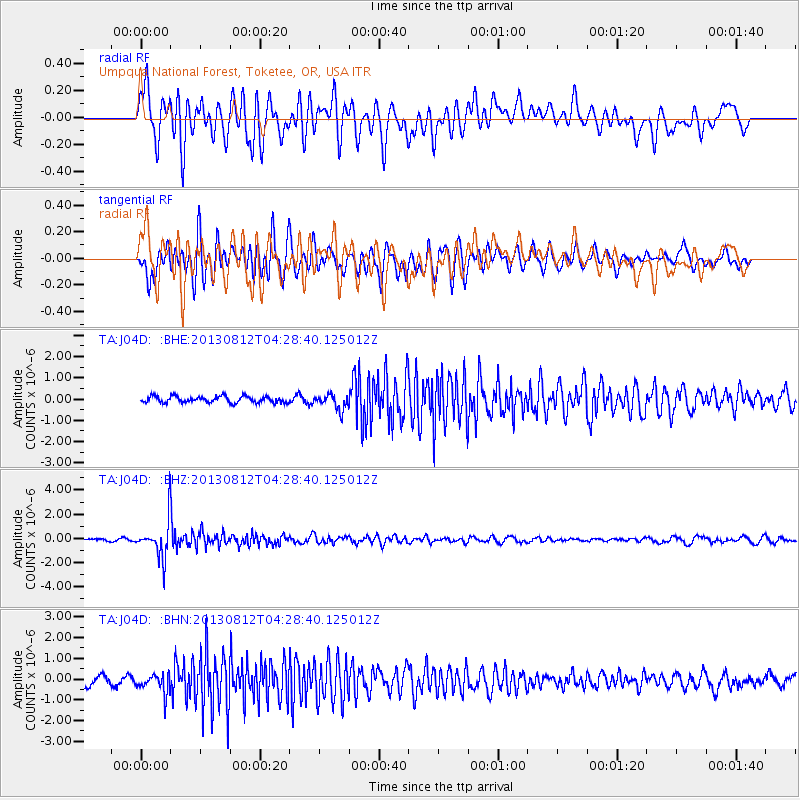
Signal To Noise
| Channel | StoN | STA | LTA |
| TA:J04D: :BHZ:20130812T04:28:40.125012Z | 17.96846 | 1.5395722E-6 | 8.568192E-8 |
| TA:J04D: :BHN:20130812T04:28:40.125012Z | 2.3372405 | 4.5415268E-7 | 1.9431148E-7 |
| TA:J04D: :BHE:20130812T04:28:40.125012Z | 2.387263 | 3.6074815E-7 | 1.511137E-7 |
| Arrivals |
| Ps | 4.8 SECOND |
| PpPs | 16 SECOND |
| PsPs/PpSs | 20 SECOND |


