You are here: Home > Network List > TA - USArray Transportable Network (new EarthScope stations) Stations List
> Station MSTX Muleshoe, TX, USA > Earthquake Result Viewer
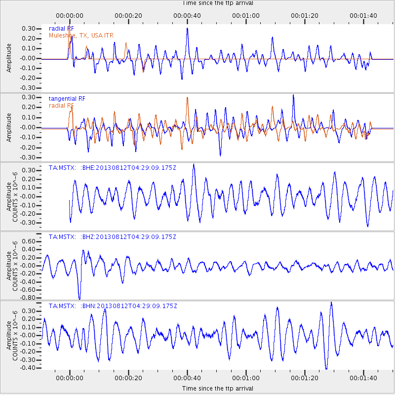
MSTX Muleshoe, TX, USA - Earthquake Result Viewer
*The percent match for this event was below the threshold and hence no stack was calculated.
| Earthquake location: |
Kermadec Islands Region |
| Earthquake latitude/longitude: |
-30.6/-179.7 |
| Earthquake time(UTC): |
2013/08/12 (224) 04:16:47 GMT |
| Earthquake Depth: |
341 km |
| Earthquake Magnitude: |
6.1 MWW, 6.1 MWC, 6.2 MWC, 6.2 MWB |
| Earthquake Catalog/Contributor: |
NEIC PDE/NEIC COMCAT |
|
| Network: |
TA USArray Transportable Network (new EarthScope stations) |
| Station: |
MSTX Muleshoe, TX, USA |
| Lat/Lon: |
33.97 N/102.77 W |
| Elevation: |
1167 m |
|
| Distance: |
96.9 deg |
| Az: |
54.618 deg |
| Baz: |
237.741 deg |
| Ray Param: |
$rayparam |
*The percent match for this event was below the threshold and hence was not used in the summary stack. |
|
| Radial Match: |
57.181366 % |
| Radial Bump: |
317 |
| Transverse Match: |
60.331184 % |
| Transverse Bump: |
334 |
| SOD ConfigId: |
626651 |
| Insert Time: |
2014-04-17 22:00:20.293 +0000 |
| GWidth: |
2.5 |
| Max Bumps: |
400 |
| Tol: |
0.001 |
|
Signal To Noise
| Channel | StoN | STA | LTA |
| TA:MSTX: :BHZ:20130812T04:29:09.175Z | 2.2360148 | 3.4398934E-7 | 1.5384036E-7 |
| TA:MSTX: :BHN:20130812T04:29:09.175Z | 0.8024647 | 8.883949E-8 | 1.1070828E-7 |
| TA:MSTX: :BHE:20130812T04:29:09.175Z | 0.6556063 | 7.437827E-8 | 1.1344959E-7 |
| Arrivals |
| Ps | |
| PpPs | |
| PsPs/PpSs | |


