You are here: Home > Network List > UW - Pacific Northwest Regional Seismic Network Stations List
> Station MRBL Marblemount, WA, USA > Earthquake Result Viewer
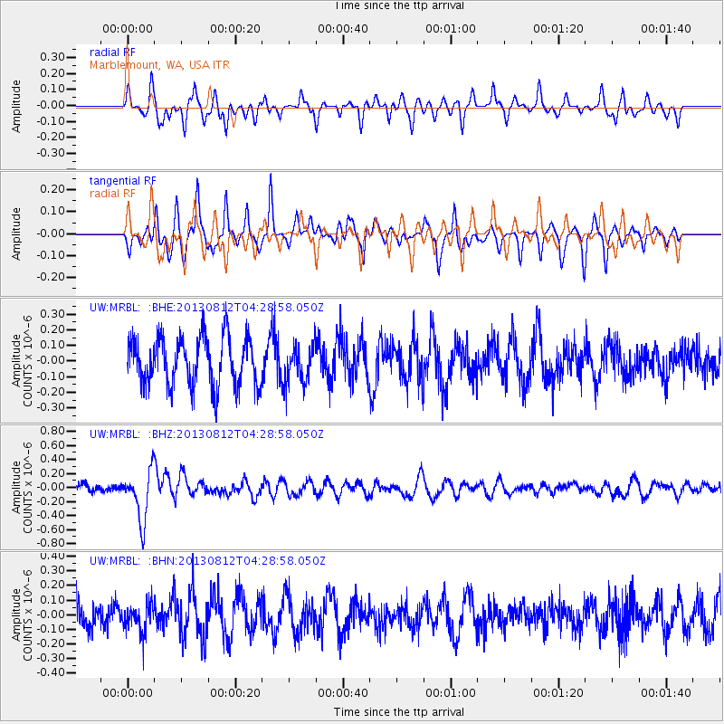
MRBL Marblemount, WA, USA - Earthquake Result Viewer
*The percent match for this event was below the threshold and hence no stack was calculated.
| Earthquake location: |
Kermadec Islands Region |
| Earthquake latitude/longitude: |
-30.6/-179.7 |
| Earthquake time(UTC): |
2013/08/12 (224) 04:16:47 GMT |
| Earthquake Depth: |
341 km |
| Earthquake Magnitude: |
6.1 MWW, 6.1 MWC, 6.2 MWC, 6.2 MWB |
| Earthquake Catalog/Contributor: |
NEIC PDE/NEIC COMCAT |
|
| Network: |
UW Pacific Northwest Regional Seismic Network |
| Station: |
MRBL Marblemount, WA, USA |
| Lat/Lon: |
48.52 N/121.48 W |
| Elevation: |
75 m |
|
| Distance: |
94.4 deg |
| Az: |
34.52 deg |
| Baz: |
227.282 deg |
| Ray Param: |
$rayparam |
*The percent match for this event was below the threshold and hence was not used in the summary stack. |
|
| Radial Match: |
55.366432 % |
| Radial Bump: |
400 |
| Transverse Match: |
45.387535 % |
| Transverse Bump: |
305 |
| SOD ConfigId: |
626651 |
| Insert Time: |
2014-04-17 22:05:26.311 +0000 |
| GWidth: |
2.5 |
| Max Bumps: |
400 |
| Tol: |
0.001 |
|
Signal To Noise
| Channel | StoN | STA | LTA |
| UW:MRBL: :BHZ:20130812T04:28:58.050Z | 6.429256 | 3.6546268E-7 | 5.6843696E-8 |
| UW:MRBL: :BHN:20130812T04:28:58.050Z | 0.82266945 | 9.538751E-8 | 1.1594877E-7 |
| UW:MRBL: :BHE:20130812T04:28:58.050Z | 0.75676686 | 1.18767296E-7 | 1.569404E-7 |
| Arrivals |
| Ps | |
| PpPs | |
| PsPs/PpSs | |


