You are here: Home > Network List > YN10 - San Jacinto Fault Zone Stations List
> Station JFN2 JFN2 > Earthquake Result Viewer
JFN2 JFN2 - Earthquake Result Viewer
| Earthquake location: |
Kermadec Islands Region |
| Earthquake latitude/longitude: |
-30.6/-179.7 |
| Earthquake time(UTC): |
2013/08/12 (224) 04:16:47 GMT |
| Earthquake Depth: |
341 km |
| Earthquake Magnitude: |
6.1 MWW, 6.1 MWC, 6.2 MWC, 6.2 MWB |
| Earthquake Catalog/Contributor: |
NEIC PDE/NEIC COMCAT |
|
| Network: |
YN San Jacinto Fault Zone |
| Station: |
JFN2 JFN2 |
| Lat/Lon: |
33.43 N/116.40 W |
| Elevation: |
644 m |
|
| Distance: |
87.3 deg |
| Az: |
48.396 deg |
| Baz: |
230.419 deg |
| Ray Param: |
0.042527042 |
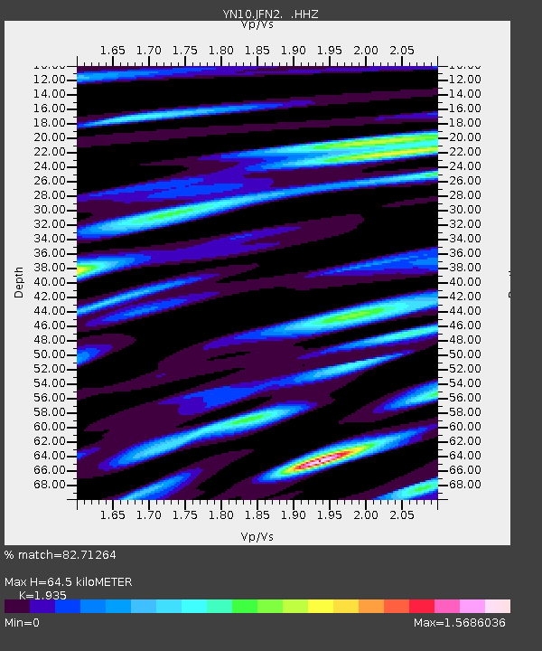
| Estimated Moho Depth: |
64.5 km |
| Estimated Crust Vp/Vs: |
1.93 |
| Assumed Crust Vp: |
6.264 km/s |
| Estimated Crust Vs: |
3.237 km/s |
| Estimated Crust Poisson's Ratio: |
0.32 |
|
| Radial Match: |
82.71264 % |
| Radial Bump: |
400 |
| Transverse Match: |
74.53246 % |
| Transverse Bump: |
400 |
| SOD ConfigId: |
626651 |
| Insert Time: |
2014-04-17 22:06:41.034 +0000 |
| GWidth: |
2.5 |
| Max Bumps: |
400 |
| Tol: |
0.001 |
|

Signal To Noise
| Channel | StoN | STA | LTA |
| YN:JFN2: :HHZ:20130812T04:28:25.609021Z | 20.25069 | 1.3157947E-6 | 6.4975296E-8 |
| YN:JFN2: :HHN:20130812T04:28:25.609021Z | 2.8955827 | 2.495978E-7 | 8.6199506E-8 |
| YN:JFN2: :HHE:20130812T04:28:25.609021Z | 3.2611775 | 3.280926E-7 | 1.0060556E-7 |
| Arrivals |
| Ps | 9.8 SECOND |
| PpPs | 30 SECOND |
| PsPs/PpSs | 39 SECOND |


