You are here: Home > Network List > CN - Canadian National Seismograph Network Stations List
> Station MALO MCALPINE LAKE, ON > Earthquake Result Viewer
MALO MCALPINE LAKE, ON - Earthquake Result Viewer
| Earthquake location: |
Off Coast Of Costa Rica |
| Earthquake latitude/longitude: |
10.5/-86.9 |
| Earthquake time(UTC): |
2013/08/12 (224) 05:18:59 GMT |
| Earthquake Depth: |
22 km |
| Earthquake Magnitude: |
5.5 MW, 5.5 MWC, 5.5 MWC |
| Earthquake Catalog/Contributor: |
NEIC PDE/NEIC COMCAT |
|
| Network: |
CN Canadian National Seismograph Network |
| Station: |
MALO MCALPINE LAKE, ON |
| Lat/Lon: |
50.02 N/79.76 W |
| Elevation: |
271 m |
|
| Distance: |
39.9 deg |
| Az: |
7.213 deg |
| Baz: |
191.039 deg |
| Ray Param: |
0.07468361 |
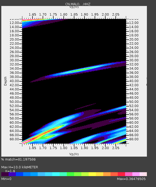
| Estimated Moho Depth: |
10.0 km |
| Estimated Crust Vp/Vs: |
1.60 |
| Assumed Crust Vp: |
6.459 km/s |
| Estimated Crust Vs: |
4.037 km/s |
| Estimated Crust Poisson's Ratio: |
0.18 |
|
| Radial Match: |
81.197586 % |
| Radial Bump: |
400 |
| Transverse Match: |
32.59845 % |
| Transverse Bump: |
400 |
| SOD ConfigId: |
626651 |
| Insert Time: |
2014-04-17 22:19:17.982 +0000 |
| GWidth: |
2.5 |
| Max Bumps: |
400 |
| Tol: |
0.001 |
|

Signal To Noise
| Channel | StoN | STA | LTA |
| CN:MALO: :HHZ:20130812T05:26:00.590006Z | 0.93916786 | 1.6249078E-7 | 1.730157E-7 |
| CN:MALO: :HHN:20130812T05:26:00.590006Z | 1.5635389 | 1.9624211E-7 | 1.2551149E-7 |
| CN:MALO: :HHE:20130812T05:26:00.590006Z | 0.6644956 | 1.3611853E-7 | 2.0484491E-7 |
| Arrivals |
| Ps | 1.0 SECOND |
| PpPs | 3.7 SECOND |
| PsPs/PpSs | 4.7 SECOND |


