You are here: Home > Network List > TA - USArray Transportable Network (new EarthScope stations) Stations List
> Station I55A Frankford, ON, CAN > Earthquake Result Viewer
I55A Frankford, ON, CAN - Earthquake Result Viewer
| Earthquake location: |
Off Coast Of Costa Rica |
| Earthquake latitude/longitude: |
10.5/-86.9 |
| Earthquake time(UTC): |
2013/08/12 (224) 05:18:59 GMT |
| Earthquake Depth: |
22 km |
| Earthquake Magnitude: |
5.5 MW, 5.5 MWC, 5.5 MWC |
| Earthquake Catalog/Contributor: |
NEIC PDE/NEIC COMCAT |
|
| Network: |
TA USArray Transportable Network (new EarthScope stations) |
| Station: |
I55A Frankford, ON, CAN |
| Lat/Lon: |
44.22 N/77.68 W |
| Elevation: |
132 m |
|
| Distance: |
34.6 deg |
| Az: |
11.757 deg |
| Baz: |
196.184 deg |
| Ray Param: |
0.07764092 |
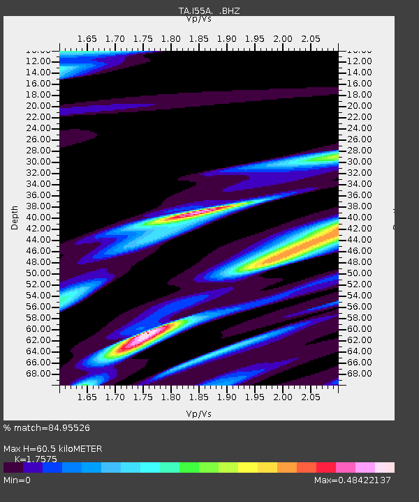
| Estimated Moho Depth: |
60.5 km |
| Estimated Crust Vp/Vs: |
1.76 |
| Assumed Crust Vp: |
6.577 km/s |
| Estimated Crust Vs: |
3.742 km/s |
| Estimated Crust Poisson's Ratio: |
0.26 |
|
| Radial Match: |
84.95526 % |
| Radial Bump: |
400 |
| Transverse Match: |
64.87396 % |
| Transverse Bump: |
400 |
| SOD ConfigId: |
626651 |
| Insert Time: |
2014-04-17 22:37:07.642 +0000 |
| GWidth: |
2.5 |
| Max Bumps: |
400 |
| Tol: |
0.001 |
|
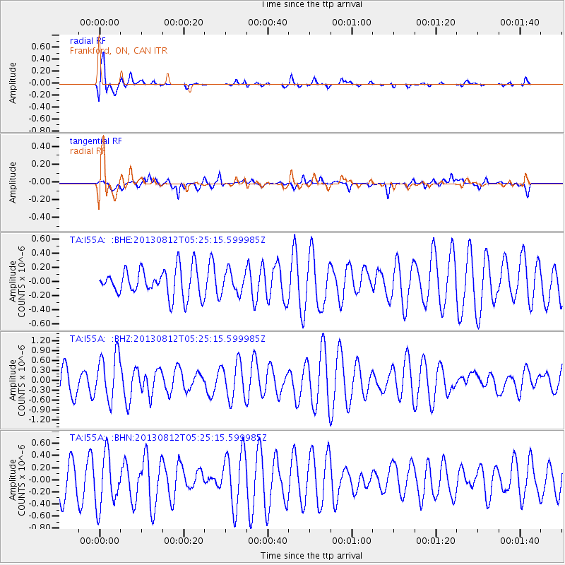
Signal To Noise
| Channel | StoN | STA | LTA |
| TA:I55A: :BHZ:20130812T05:25:15.599985Z | 1.562546 | 7.049622E-7 | 4.511625E-7 |
| TA:I55A: :BHN:20130812T05:25:15.599985Z | 1.7521547 | 4.4027493E-7 | 2.5127628E-7 |
| TA:I55A: :BHE:20130812T05:25:15.599985Z | 0.7788057 | 1.5107744E-7 | 1.9398607E-7 |
| Arrivals |
| Ps | 7.6 SECOND |
| PpPs | 23 SECOND |
| PsPs/PpSs | 31 SECOND |


