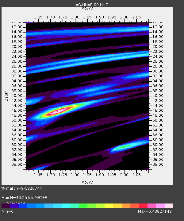
HHAR Hobbs,AR - Earthquake Result Viewer

Earthquake location: Near Coast Of Northern Peru
Earthquake latitude/longitude: -5.4/-81.9
Earthquake time(UTC): 2013/08/12 (224) 09:49:32 GMT
Earthquake Depth: 10 km
Earthquake Magnitude: 6.2 MWW, 6.1 MWB, 6.2 MWW, 6.2 MWC, 6.3 MWC
Earthquake Catalog/Contributor: NEIC PDE/NEIC COMCAT
Network: AG Arkansas Seismic Network
Station: HHAR Hobbs,AR
Lat/Lon: 36.28 N/93.94 W
Elevation: 421 m
Distance: 43.0 deg
Az: 345.714 deg
Baz: 162.298 deg
Ray Param: 0.07285662
Estimated Moho Depth: 46.25 km
Estimated Crust Vp/Vs: 1.73
Assumed Crust Vp: 6.53 km/s
Estimated Crust Vs: 3.78 km/s
Estimated Crust Poisson's Ratio: 0.25
Radial Match: 94.826744 %
Radial Bump: 189
Transverse Match: 79.170204 %
Transverse Bump: 400
SOD ConfigId: 626651
Insert Time: 2014-04-17 22:51:42.310 +0000
GWidth: 2.5
Max Bumps: 400
Tol: 0.001

Signal To Noise

ChannelStoNSTALTA
AG:HHAR:00:HHZ:20130812T09:57:00.580001Z17.3619753.3021822E-61.9019625E-7
AG:HHAR:00:HHN:20130812T09:57:00.580001Z8.2198741.4389091E-61.7505243E-7
AG:HHAR:00:HHE:20130812T09:57:00.580001Z8.9843278.417238E-79.368802E-8
Arrivals
Ps5.5 SECOND
PpPs18 SECOND
PsPs/PpSs24 SECOND