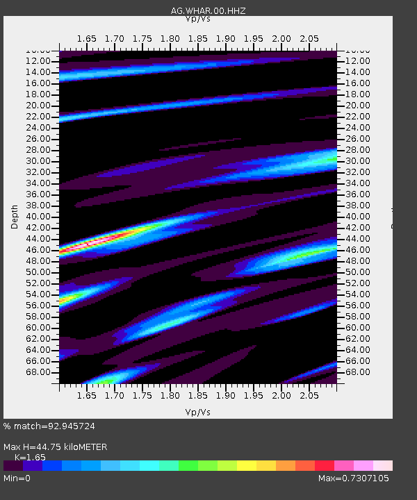
WHAR Woolly Hollow State Park,AR - Earthquake Result Viewer

Earthquake location: Near Coast Of Northern Peru
Earthquake latitude/longitude: -5.4/-81.9
Earthquake time(UTC): 2013/08/12 (224) 09:49:32 GMT
Earthquake Depth: 10 km
Earthquake Magnitude: 6.2 MWW, 6.1 MWB, 6.2 MWW, 6.2 MWC, 6.3 MWC
Earthquake Catalog/Contributor: NEIC PDE/NEIC COMCAT
Network: AG Arkansas Seismic Network
Station: WHAR Woolly Hollow State Park,AR
Lat/Lon: 35.29 N/92.29 W
Elevation: 184 m
Distance: 41.6 deg
Az: 347.202 deg
Baz: 164.36 deg
Ray Param: 0.07367248
Estimated Moho Depth: 44.75 km
Estimated Crust Vp/Vs: 1.65
Assumed Crust Vp: 6.498 km/s
Estimated Crust Vs: 3.938 km/s
Estimated Crust Poisson's Ratio: 0.21
Radial Match: 92.945724 %
Radial Bump: 231
Transverse Match: 74.06993 %
Transverse Bump: 400
SOD ConfigId: 626651
Insert Time: 2014-04-17 22:51:49.436 +0000
GWidth: 2.5
Max Bumps: 400
Tol: 0.001

Signal To Noise

ChannelStoNSTALTA
AG:WHAR:00:HHZ:20130812T09:56:49.72499Z12.1551463.405266E-62.8015015E-7
AG:WHAR:00:HHN:20130812T09:56:49.72499Z4.50599961.6189391E-63.5928525E-7
AG:WHAR:00:HHE:20130812T09:56:49.72499Z1.51765824.5534912E-73.0003403E-7
Arrivals
Ps4.8 SECOND
PpPs17 SECOND
PsPs/PpSs22 SECOND