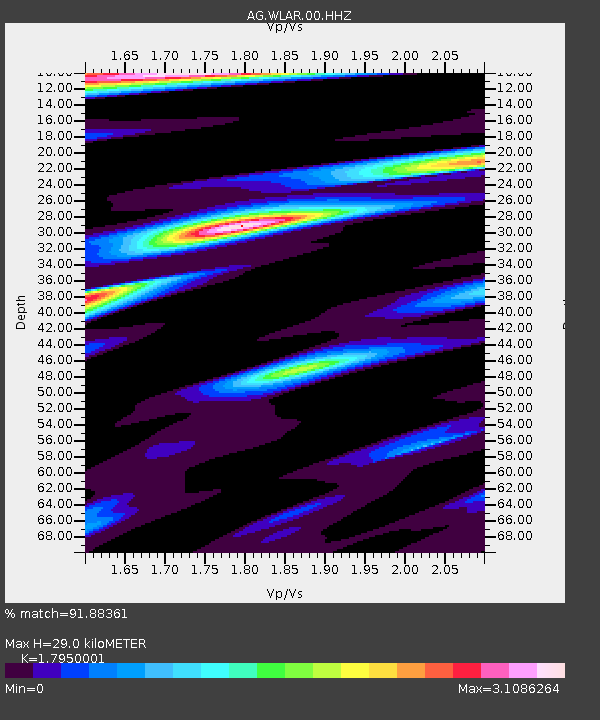
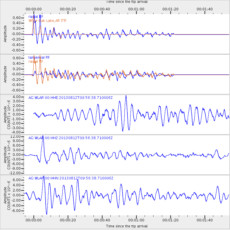
WLAR White Oak Lake,AR - Earthquake Result Viewer

Earthquake location: Near Coast Of Northern Peru
Earthquake latitude/longitude: -5.4/-81.9
Earthquake time(UTC): 2013/08/12 (224) 09:49:32 GMT
Earthquake Depth: 10 km
Earthquake Magnitude: 6.2 MWW, 6.1 MWB, 6.2 MWW, 6.2 MWC, 6.3 MWC
Earthquake Catalog/Contributor: NEIC PDE/NEIC COMCAT
Network: AG Arkansas Seismic Network
Station: WLAR White Oak Lake,AR
Lat/Lon: 33.69 N/93.11 W
Elevation: 77 m
Distance: 40.3 deg
Az: 345.515 deg
Baz: 162.622 deg
Ray Param: 0.07448259
Estimated Moho Depth: 29.0 km
Estimated Crust Vp/Vs: 1.80
Assumed Crust Vp: 6.245 km/s
Estimated Crust Vs: 3.479 km/s
Estimated Crust Poisson's Ratio: 0.27
Radial Match: 91.88361 %
Radial Bump: 274
Transverse Match: 75.25181 %
Transverse Bump: 393
SOD ConfigId: 626651
Insert Time: 2014-04-17 22:51:51.344 +0000
GWidth: 2.5
Max Bumps: 400
Tol: 0.001

Signal To Noise

ChannelStoNSTALTA
AG:WLAR:00:HHZ:20130812T09:56:38.710006Z10.381132.327044E-62.2416096E-7
AG:WLAR:00:HHN:20130812T09:56:38.710006Z1.7909781.2187215E-66.8047825E-7
AG:WLAR:00:HHE:20130812T09:56:38.710006Z1.40885958.41297E-75.9714756E-7
Arrivals
Ps3.9 SECOND
PpPs12 SECOND
PsPs/PpSs16 SECOND