You are here: Home > Network List > TA - USArray Transportable Network (new EarthScope stations) Stations List
> Station I59A Olmsteadville, NY, USA > Earthquake Result Viewer
I59A Olmsteadville, NY, USA - Earthquake Result Viewer
*The percent match for this event was below the threshold and hence no stack was calculated.
| Earthquake location: |
Central Mid-Atlantic Ridge |
| Earthquake latitude/longitude: |
4.6/-32.5 |
| Earthquake time(UTC): |
2014/11/03 (307) 07:18:09 GMT |
| Earthquake Depth: |
10 km |
| Earthquake Magnitude: |
5.2 MW, 5.0 mb, 4.9 MS |
| Earthquake Catalog/Contributor: |
ISC/ISC |
|
| Network: |
TA USArray Transportable Network (new EarthScope stations) |
| Station: |
I59A Olmsteadville, NY, USA |
| Lat/Lon: |
43.80 N/73.87 W |
| Elevation: |
390 m |
|
| Distance: |
53.3 deg |
| Az: |
323.394 deg |
| Baz: |
124.832 deg |
| Ray Param: |
$rayparam |
*The percent match for this event was below the threshold and hence was not used in the summary stack. |
|
| Radial Match: |
85.80672 % |
| Radial Bump: |
400 |
| Transverse Match: |
67.420586 % |
| Transverse Bump: |
349 |
| SOD ConfigId: |
3390531 |
| Insert Time: |
2019-04-14 20:23:23.439 +0000 |
| GWidth: |
2.5 |
| Max Bumps: |
400 |
| Tol: |
0.001 |
|
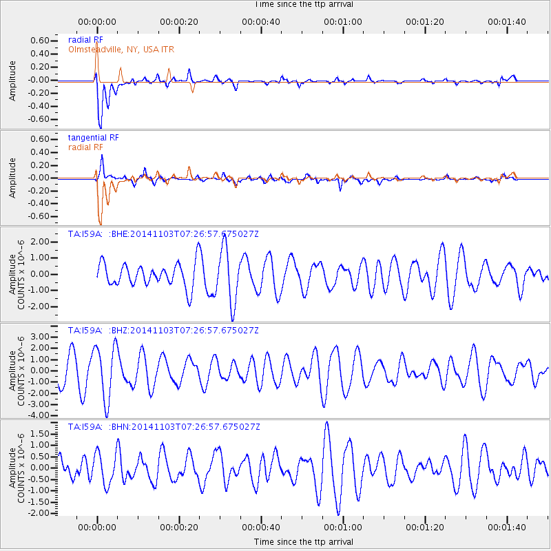
Signal To Noise
| Channel | StoN | STA | LTA |
| TA:I59A: :BHZ:20141103T07:26:57.675027Z | 2.4932482 | 2.4423591E-6 | 9.795892E-7 |
| TA:I59A: :BHN:20141103T07:26:57.675027Z | 2.101532 | 7.174152E-7 | 3.4137727E-7 |
| TA:I59A: :BHE:20141103T07:26:57.675027Z | 2.395704 | 1.6913376E-6 | 7.059877E-7 |
| Arrivals |
| Ps | |
| PpPs | |
| PsPs/PpSs | |


