You are here: Home > Network List > TA - USArray Transportable Network (new EarthScope stations) Stations List
> Station Q53A Leroy, WV, USA > Earthquake Result Viewer
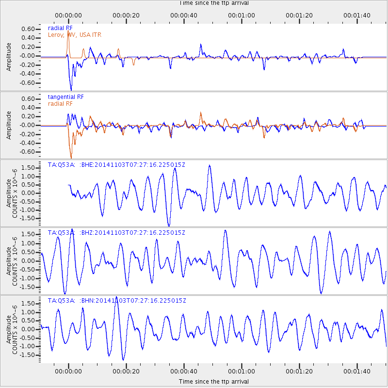
Q53A Leroy, WV, USA - Earthquake Result Viewer
*The percent match for this event was below the threshold and hence no stack was calculated.
| Earthquake location: |
Central Mid-Atlantic Ridge |
| Earthquake latitude/longitude: |
4.6/-32.5 |
| Earthquake time(UTC): |
2014/11/03 (307) 07:18:09 GMT |
| Earthquake Depth: |
10 km |
| Earthquake Magnitude: |
5.2 MW, 5.0 mb, 4.9 MS |
| Earthquake Catalog/Contributor: |
ISC/ISC |
|
| Network: |
TA USArray Transportable Network (new EarthScope stations) |
| Station: |
Q53A Leroy, WV, USA |
| Lat/Lon: |
38.86 N/81.53 W |
| Elevation: |
310 m |
|
| Distance: |
55.9 deg |
| Az: |
314.64 deg |
| Baz: |
114.712 deg |
| Ray Param: |
$rayparam |
*The percent match for this event was below the threshold and hence was not used in the summary stack. |
|
| Radial Match: |
66.049095 % |
| Radial Bump: |
390 |
| Transverse Match: |
53.7728 % |
| Transverse Bump: |
400 |
| SOD ConfigId: |
3390531 |
| Insert Time: |
2019-04-14 20:23:44.954 +0000 |
| GWidth: |
2.5 |
| Max Bumps: |
400 |
| Tol: |
0.001 |
|
Signal To Noise
| Channel | StoN | STA | LTA |
| TA:Q53A: :BHZ:20141103T07:27:16.225015Z | 1.657472 | 1.1476045E-6 | 6.9238246E-7 |
| TA:Q53A: :BHN:20141103T07:27:16.225015Z | 1.0228983 | 4.6643572E-7 | 4.5599424E-7 |
| TA:Q53A: :BHE:20141103T07:27:16.225015Z | 1.9668597 | 9.842121E-7 | 5.0039773E-7 |
| Arrivals |
| Ps | |
| PpPs | |
| PsPs/PpSs | |


