You are here: Home > Network List > AK - Alaska Regional Network Stations List
> Station WAX Waxell Ridge, AK, USA > Earthquake Result Viewer
WAX Waxell Ridge, AK, USA - Earthquake Result Viewer
| Earthquake location: |
Near Coast Of Northern Peru |
| Earthquake latitude/longitude: |
-5.4/-81.9 |
| Earthquake time(UTC): |
2013/08/12 (224) 09:49:32 GMT |
| Earthquake Depth: |
10 km |
| Earthquake Magnitude: |
6.2 MWW, 6.1 MWB, 6.2 MWW, 6.2 MWC, 6.3 MWC |
| Earthquake Catalog/Contributor: |
NEIC PDE/NEIC COMCAT |
|
| Network: |
AK Alaska Regional Network |
| Station: |
WAX Waxell Ridge, AK, USA |
| Lat/Lon: |
60.45 N/142.85 W |
| Elevation: |
1003 m |
|
| Distance: |
80.9 deg |
| Az: |
333.972 deg |
| Baz: |
118.197 deg |
| Ray Param: |
0.047985323 |
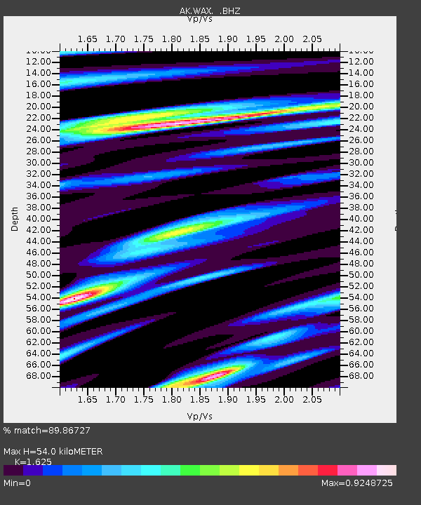
| Estimated Moho Depth: |
54.0 km |
| Estimated Crust Vp/Vs: |
1.62 |
| Assumed Crust Vp: |
6.566 km/s |
| Estimated Crust Vs: |
4.041 km/s |
| Estimated Crust Poisson's Ratio: |
0.20 |
|
| Radial Match: |
89.86727 % |
| Radial Bump: |
400 |
| Transverse Match: |
89.37065 % |
| Transverse Bump: |
400 |
| SOD ConfigId: |
626651 |
| Insert Time: |
2014-04-17 22:56:06.483 +0000 |
| GWidth: |
2.5 |
| Max Bumps: |
400 |
| Tol: |
0.001 |
|

Signal To Noise
| Channel | StoN | STA | LTA |
| AK:WAX: :BHZ:20130812T10:01:15.02803Z | 9.267519 | 1.2010905E-6 | 1.2960216E-7 |
| AK:WAX: :BHN:20130812T10:01:15.02803Z | 1.6453279 | 2.518561E-7 | 1.530735E-7 |
| AK:WAX: :BHE:20130812T10:01:15.02803Z | 3.4153774 | 4.4328345E-7 | 1.2979048E-7 |
| Arrivals |
| Ps | 5.3 SECOND |
| PpPs | 21 SECOND |
| PsPs/PpSs | 26 SECOND |


