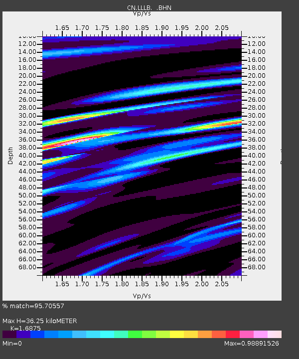
LLLB LILLOOET, BC, CANADA ADA - Earthquake Result Viewer
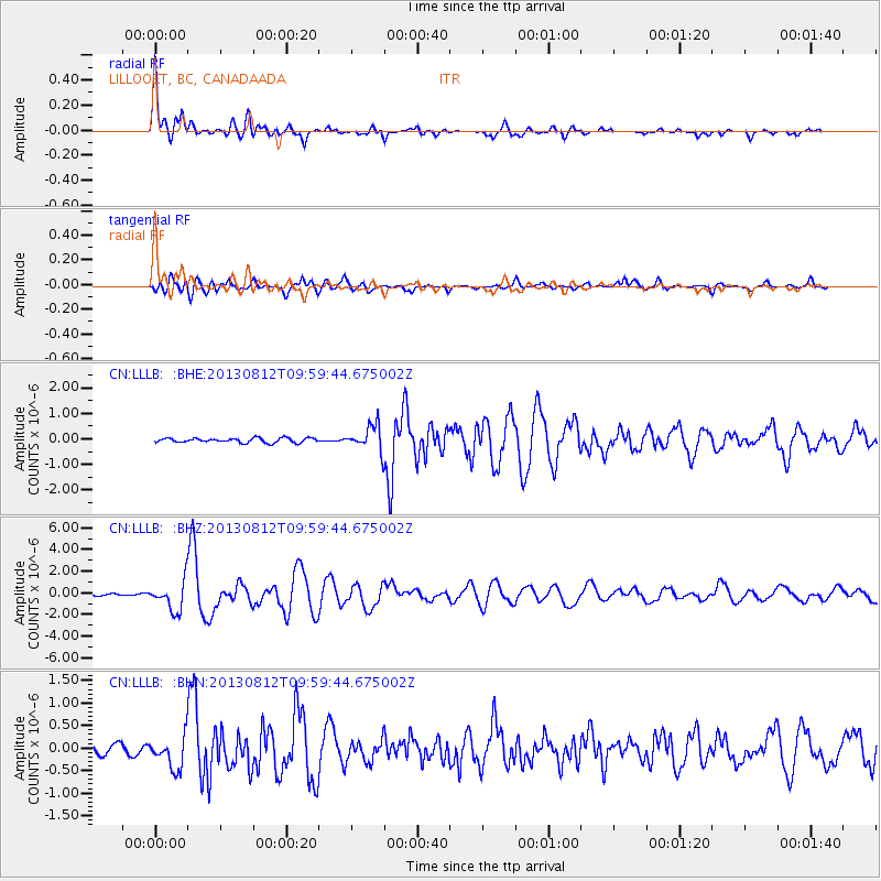
Earthquake location: Near Coast Of Northern Peru
Earthquake latitude/longitude: -5.4/-81.9
Earthquake time(UTC): 2013/08/12 (224) 09:49:32 GMT
Earthquake Depth: 10 km
Earthquake Magnitude: 6.2 MWW, 6.1 MWB, 6.2 MWW, 6.2 MWC, 6.3 MWC
Earthquake Catalog/Contributor: NEIC PDE/NEIC COMCAT
Network: CN Canadian National Seismograph Network
Station: LLLB LILLOOET, BC, CANADA ADA
Lat/Lon: 50.61 N/121.88 W
Elevation: 700 m
Distance: 65.5 deg
Az: 333.285 deg
Baz: 135.373 deg
Ray Param: 0.058213845
Estimated Moho Depth: 36.25 km
Estimated Crust Vp/Vs: 1.69
Assumed Crust Vp: 6.597 km/s
Estimated Crust Vs: 3.91 km/s
Estimated Crust Poisson's Ratio: 0.23
Radial Match: 95.70557 %
Radial Bump: 400
Transverse Match: 83.458916 %
Transverse Bump: 400
SOD ConfigId: 626651
Insert Time: 2014-04-17 23:01:19.381 +0000
GWidth: 2.5
Max Bumps: 400
Tol: 0.001

Signal To Noise

ChannelStoNSTALTA
CN:LLLB: :BHZ:20130812T09:59:44.675002Z14.3274061.3504978E-69.4259754E-8
CN:LLLB: :BHN:20130812T09:59:44.675002Z2.60923743.5272532E-71.351833E-7
CN:LLLB: :BHE:20130812T09:59:44.675002Z5.6826155.000918E-78.800382E-8
Arrivals
Ps4.0 SECOND
PpPs14 SECOND
PsPs/PpSs18 SECOND