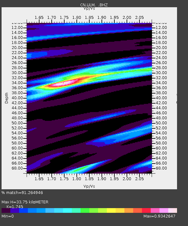
ULM LAC DU BONNET, MB - Earthquake Result Viewer

Earthquake location: Near Coast Of Northern Peru
Earthquake latitude/longitude: -5.4/-81.9
Earthquake time(UTC): 2013/08/12 (224) 09:49:32 GMT
Earthquake Depth: 10 km
Earthquake Magnitude: 6.2 MWW, 6.1 MWB, 6.2 MWW, 6.2 MWC, 6.3 MWC
Earthquake Catalog/Contributor: NEIC PDE/NEIC COMCAT
Network: CN Canadian National Seismograph Network
Station: ULM LAC DU BONNET, MB
Lat/Lon: 50.25 N/95.88 W
Elevation: 251 m
Distance: 56.7 deg
Az: 349.333 deg
Baz: 163.318 deg
Ray Param: 0.06395565
Estimated Moho Depth: 33.75 km
Estimated Crust Vp/Vs: 1.75
Assumed Crust Vp: 6.459 km/s
Estimated Crust Vs: 3.702 km/s
Estimated Crust Poisson's Ratio: 0.26
Radial Match: 91.264946 %
Radial Bump: 294
Transverse Match: 64.58458 %
Transverse Bump: 400
SOD ConfigId: 626651
Insert Time: 2014-04-17 23:01:58.820 +0000
GWidth: 2.5
Max Bumps: 400
Tol: 0.001

Signal To Noise

ChannelStoNSTALTA
CN:ULM: :BHZ:20130812T09:58:45.075027Z7.0068982.9567354E-64.2197496E-7
CN:ULM: :BHN:20130812T09:58:45.075027Z5.5275711.4028902E-62.5379867E-7
CN:ULM: :BHE:20130812T09:58:45.075027Z2.52094446.781189E-72.68994E-7
Arrivals
Ps4.1 SECOND
PpPs14 SECOND
PsPs/PpSs18 SECOND