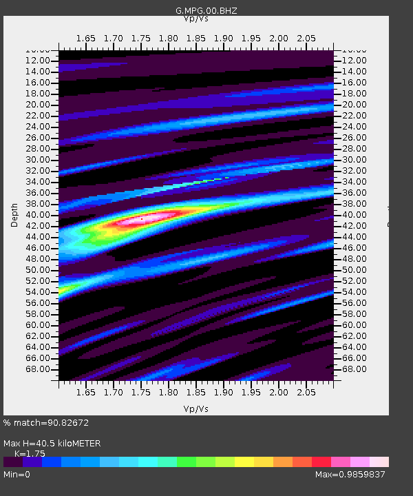
MPG Montagne des Peres, French Guyana - Earthquake Result Viewer

Earthquake location: Near Coast Of Northern Peru
Earthquake latitude/longitude: -5.4/-81.9
Earthquake time(UTC): 2013/08/12 (224) 09:49:32 GMT
Earthquake Depth: 10 km
Earthquake Magnitude: 6.2 MWW, 6.1 MWB, 6.2 MWW, 6.2 MWC, 6.3 MWC
Earthquake Catalog/Contributor: NEIC PDE/NEIC COMCAT
Network: G GEOSCOPE
Station: MPG Montagne des Peres, French Guyana
Lat/Lon: 5.11 N/52.64 W
Elevation: 147 m
Distance: 31.0 deg
Az: 70.843 deg
Baz: 250.769 deg
Ray Param: 0.07917168
Estimated Moho Depth: 40.5 km
Estimated Crust Vp/Vs: 1.75
Assumed Crust Vp: 6.472 km/s
Estimated Crust Vs: 3.698 km/s
Estimated Crust Poisson's Ratio: 0.26
Radial Match: 90.82672 %
Radial Bump: 382
Transverse Match: 58.706905 %
Transverse Bump: 400
SOD ConfigId: 626651
Insert Time: 2014-04-17 23:03:33.855 +0000
GWidth: 2.5
Max Bumps: 400
Tol: 0.001

Signal To Noise

ChannelStoNSTALTA
G:MPG:00:BHZ:20130812T09:55:19.650009Z9.2980171.4462861E-61.555478E-7
G:MPG:00:BHN:20130812T09:55:19.650009Z3.6879593.370591E-79.139448E-8
G:MPG:00:BHE:20130812T09:55:19.650009Z8.1734788.793802E-71.0758947E-7
Arrivals
Ps5.1 SECOND
PpPs16 SECOND
PsPs/PpSs21 SECOND