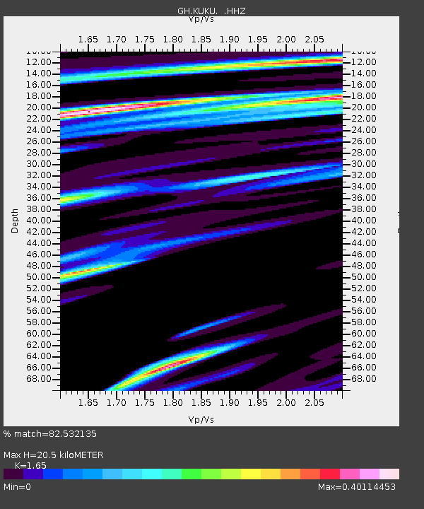
KUKU Kukurantumi, Ghana - Earthquake Result Viewer

Earthquake location: Near Coast Of Northern Peru
Earthquake latitude/longitude: -5.4/-81.9
Earthquake time(UTC): 2013/08/12 (224) 09:49:32 GMT
Earthquake Depth: 10 km
Earthquake Magnitude: 6.2 MWW, 6.1 MWB, 6.2 MWW, 6.2 MWC, 6.3 MWC
Earthquake Catalog/Contributor: NEIC PDE/NEIC COMCAT
Network: GH Ghana Digital Seismic Network
Station: KUKU Kukurantumi, Ghana
Lat/Lon: 6.19 N/0.37 W
Elevation: 240 m
Distance: 82.2 deg
Az: 83.025 deg
Baz: 263.711 deg
Ray Param: 0.047036085
Estimated Moho Depth: 20.5 km
Estimated Crust Vp/Vs: 1.65
Assumed Crust Vp: 6.419 km/s
Estimated Crust Vs: 3.89 km/s
Estimated Crust Poisson's Ratio: 0.21
Radial Match: 82.532135 %
Radial Bump: 400
Transverse Match: 77.315125 %
Transverse Bump: 400
SOD ConfigId: 626651
Insert Time: 2014-04-17 23:04:57.265 +0000
GWidth: 2.5
Max Bumps: 400
Tol: 0.001

Signal To Noise

ChannelStoNSTALTA
GH:KUKU: :HHZ:20130812T10:01:22.159988Z3.15362074.4271945E-71.4038449E-7
GH:KUKU: :HHN:20130812T10:01:22.159988Z0.601638266.729111E-81.11846475E-7
GH:KUKU: :HHE:20130812T10:01:22.159988Z2.2856232.7510197E-71.203619E-7
Arrivals
Ps2.1 SECOND
PpPs8.2 SECOND
PsPs/PpSs10 SECOND