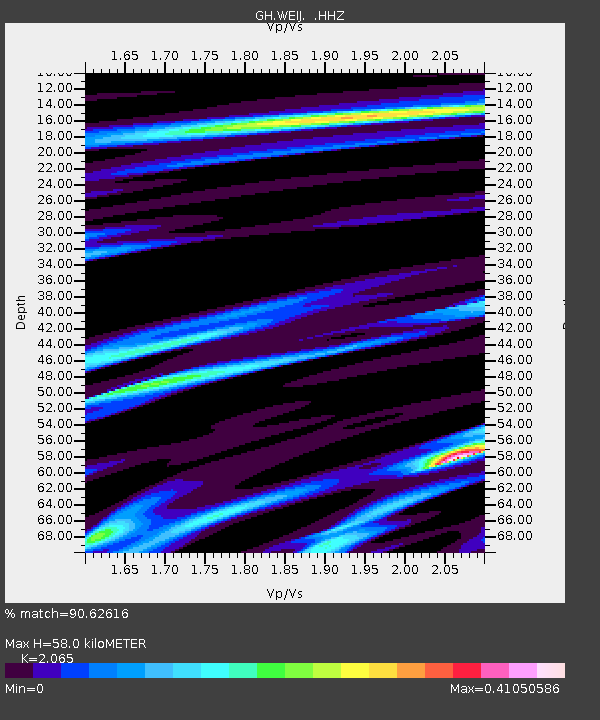
WEIJ Weija Dam, Ghana - Earthquake Result Viewer

Earthquake location: Near Coast Of Northern Peru
Earthquake latitude/longitude: -5.4/-81.9
Earthquake time(UTC): 2013/08/12 (224) 09:49:32 GMT
Earthquake Depth: 10 km
Earthquake Magnitude: 6.2 MWW, 6.1 MWB, 6.2 MWW, 6.2 MWC, 6.3 MWC
Earthquake Catalog/Contributor: NEIC PDE/NEIC COMCAT
Network: GH Ghana Digital Seismic Network
Station: WEIJ Weija Dam, Ghana
Lat/Lon: 5.59 N/0.33 W
Elevation: 203 m
Distance: 82.2 deg
Az: 83.631 deg
Baz: 263.796 deg
Ray Param: 0.047057066
Estimated Moho Depth: 58.0 km
Estimated Crust Vp/Vs: 2.07
Assumed Crust Vp: 6.472 km/s
Estimated Crust Vs: 3.134 km/s
Estimated Crust Poisson's Ratio: 0.35
Radial Match: 90.62616 %
Radial Bump: 400
Transverse Match: 55.485718 %
Transverse Bump: 400
SOD ConfigId: 626651
Insert Time: 2014-04-17 23:05:02.964 +0000
GWidth: 2.5
Max Bumps: 400
Tol: 0.001

Signal To Noise

ChannelStoNSTALTA
GH:WEIJ: :HHZ:20130812T10:01:22.000015Z3.84694555.8854135E-71.5298926E-7
GH:WEIJ: :HHN:20130812T10:01:22.000015Z0.7079558.226038E-81.1619436E-7
GH:WEIJ: :HHE:20130812T10:01:22.000015Z2.5684732.6968607E-71.049986E-7
Arrivals
Ps9.8 SECOND
PpPs27 SECOND
PsPs/PpSs37 SECOND