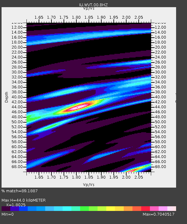
WVT Waverly, Tennessee, USA - Earthquake Result Viewer

Earthquake location: Near Coast Of Northern Peru
Earthquake latitude/longitude: -5.4/-81.9
Earthquake time(UTC): 2013/08/12 (224) 09:49:32 GMT
Earthquake Depth: 10 km
Earthquake Magnitude: 6.2 MWW, 6.1 MWB, 6.2 MWW, 6.2 MWC, 6.3 MWC
Earthquake Catalog/Contributor: NEIC PDE/NEIC COMCAT
Network: IU Global Seismograph Network (GSN - IRIS/USGS)
Station: WVT Waverly, Tennessee, USA
Lat/Lon: 36.13 N/87.83 W
Elevation: 170 m
Distance: 41.7 deg
Az: 352.807 deg
Baz: 171.141 deg
Ray Param: 0.07364167
Estimated Moho Depth: 44.0 km
Estimated Crust Vp/Vs: 1.80
Assumed Crust Vp: 6.444 km/s
Estimated Crust Vs: 3.575 km/s
Estimated Crust Poisson's Ratio: 0.28
Radial Match: 89.1887 %
Radial Bump: 317
Transverse Match: 71.21757 %
Transverse Bump: 400
SOD ConfigId: 626651
Insert Time: 2014-04-17 23:07:04.001 +0000
GWidth: 2.5
Max Bumps: 400
Tol: 0.001

Signal To Noise

ChannelStoNSTALTA
IU:WVT:00:BHZ:20130812T09:56:50.16899Z13.5390882.2066374E-61.6298273E-7
IU:WVT:00:BH1:20130812T09:56:50.16899Z8.4140641.3088244E-61.5555199E-7
IU:WVT:00:BH2:20130812T09:56:50.16899Z1.45373083.2103603E-72.2083596E-7
Arrivals
Ps5.9 SECOND
PpPs18 SECOND
PsPs/PpSs24 SECOND