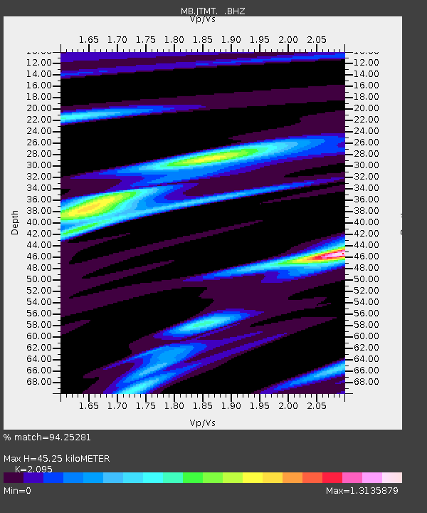
JTMT Jette Lake, Montana - Earthquake Result Viewer

Earthquake location: Near Coast Of Northern Peru
Earthquake latitude/longitude: -5.4/-81.9
Earthquake time(UTC): 2013/08/12 (224) 09:49:32 GMT
Earthquake Depth: 10 km
Earthquake Magnitude: 6.2 MWW, 6.1 MWB, 6.2 MWW, 6.2 MWC, 6.3 MWC
Earthquake Catalog/Contributor: NEIC PDE/NEIC COMCAT
Network: MB Montana Regional Seismic Network
Station: JTMT Jette Lake, Montana
Lat/Lon: 47.75 N/114.28 W
Elevation: 1469 m
Distance: 60.1 deg
Az: 335.375 deg
Baz: 142.068 deg
Ray Param: 0.06176287
Estimated Moho Depth: 45.25 km
Estimated Crust Vp/Vs: 2.10
Assumed Crust Vp: 6.622 km/s
Estimated Crust Vs: 3.161 km/s
Estimated Crust Poisson's Ratio: 0.35
Radial Match: 94.25281 %
Radial Bump: 227
Transverse Match: 77.57536 %
Transverse Bump: 400
SOD ConfigId: 626651
Insert Time: 2014-04-17 23:09:18.383 +0000
GWidth: 2.5
Max Bumps: 400
Tol: 0.001

Signal To Noise

ChannelStoNSTALTA
MB:JTMT: :BHZ:20130812T09:59:08.500015Z12.4173551.5658137E-61.2609881E-7
MB:JTMT: :BHN:20130812T09:59:08.500015Z8.3726776.241746E-77.454899E-8
MB:JTMT: :BHE:20130812T09:59:08.500015Z4.48409375.849715E-71.3045478E-7
Arrivals
Ps7.8 SECOND
PpPs20 SECOND
PsPs/PpSs28 SECOND