You are here: Home > Network List > NE - New England Seismic Network Stations List
> Station PQI Presque Isle, ME, USA > Earthquake Result Viewer
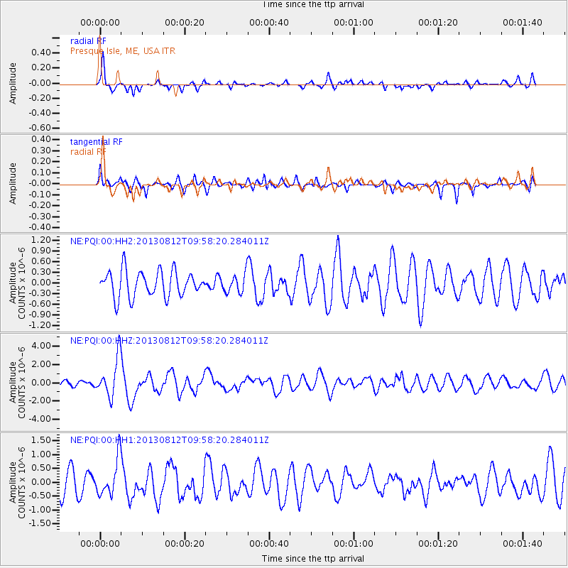
PQI Presque Isle, ME, USA - Earthquake Result Viewer
*The percent match for this event was below the threshold and hence no stack was calculated.
| Earthquake location: |
Near Coast Of Northern Peru |
| Earthquake latitude/longitude: |
-5.4/-81.9 |
| Earthquake time(UTC): |
2013/08/12 (224) 09:49:32 GMT |
| Earthquake Depth: |
10 km |
| Earthquake Magnitude: |
6.2 MWW, 6.1 MWB, 6.2 MWW, 6.2 MWC, 6.3 MWC |
| Earthquake Catalog/Contributor: |
NEIC PDE/NEIC COMCAT |
|
| Network: |
NE New England Seismic Network |
| Station: |
PQI Presque Isle, ME, USA |
| Lat/Lon: |
46.67 N/68.02 W |
| Elevation: |
162 m |
|
| Distance: |
53.3 deg |
| Az: |
11.915 deg |
| Baz: |
197.368 deg |
| Ray Param: |
$rayparam |
*The percent match for this event was below the threshold and hence was not used in the summary stack. |
|
| Radial Match: |
75.457245 % |
| Radial Bump: |
365 |
| Transverse Match: |
63.020752 % |
| Transverse Bump: |
400 |
| SOD ConfigId: |
626651 |
| Insert Time: |
2014-04-17 23:09:53.101 +0000 |
| GWidth: |
2.5 |
| Max Bumps: |
400 |
| Tol: |
0.001 |
|
Signal To Noise
| Channel | StoN | STA | LTA |
| NE:PQI:00:HHZ:20130812T09:58:20.284011Z | 3.2041523 | 2.1778012E-6 | 6.796809E-7 |
| NE:PQI:00:HH1:20130812T09:58:20.284011Z | 1.2198042 | 6.893864E-7 | 5.6516154E-7 |
| NE:PQI:00:HH2:20130812T09:58:20.284011Z | 0.76162046 | 2.7675404E-7 | 3.6337528E-7 |
| Arrivals |
| Ps | |
| PpPs | |
| PsPs/PpSs | |


