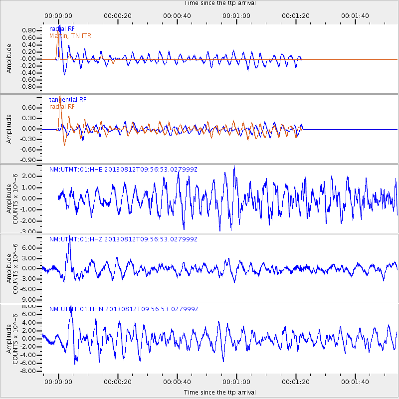
UTMT Martin, TN - Earthquake Result Viewer
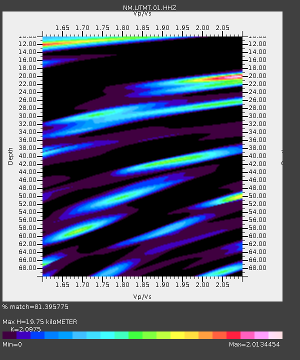
Earthquake location: Near Coast Of Northern Peru
Earthquake latitude/longitude: -5.4/-81.9
Earthquake time(UTC): 2013/08/12 (224) 09:49:32 GMT
Earthquake Depth: 10 km
Earthquake Magnitude: 6.2 MWW, 6.1 MWB, 6.2 MWW, 6.2 MWC, 6.3 MWC
Earthquake Catalog/Contributor: NEIC PDE/NEIC COMCAT
Network: NM Cooperative New Madrid Seismic Network
Station: UTMT Martin, TN
Lat/Lon: 36.35 N/88.86 W
Elevation: 110 m
Distance: 42.0 deg
Az: 351.627 deg
Baz: 169.654 deg
Ray Param: 0.07341359
Estimated Moho Depth: 19.75 km
Estimated Crust Vp/Vs: 2.10
Assumed Crust Vp: 6.444 km/s
Estimated Crust Vs: 3.072 km/s
Estimated Crust Poisson's Ratio: 0.35
Radial Match: 81.395775 %
Radial Bump: 400
Transverse Match: 63.06126 %
Transverse Bump: 400
SOD ConfigId: 626651
Insert Time: 2014-04-17 23:11:46.604 +0000
GWidth: 2.5
Max Bumps: 400
Tol: 0.001

Signal To Noise

ChannelStoNSTALTA
NM:UTMT:01:HHZ:20130812T09:56:53.027999Z10.8505233.4352722E-63.165997E-7
NM:UTMT:01:HHN:20130812T09:56:53.027999Z3.9823013.1685884E-67.9566775E-7
NM:UTMT:01:HHE:20130812T09:56:53.027999Z1.27693328.6569673E-76.779499E-7
Arrivals
Ps3.6 SECOND
PpPs9.0 SECOND
PsPs/PpSs13 SECOND