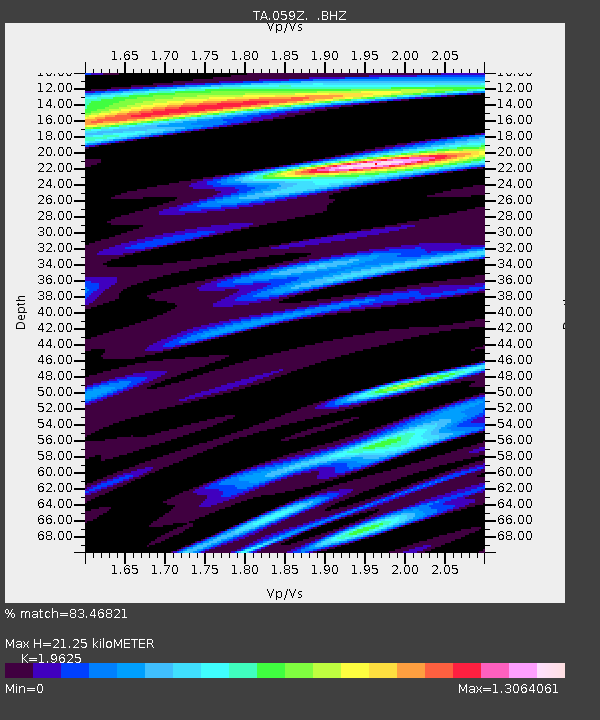
059Z Ave Maria, FL, USA - Earthquake Result Viewer
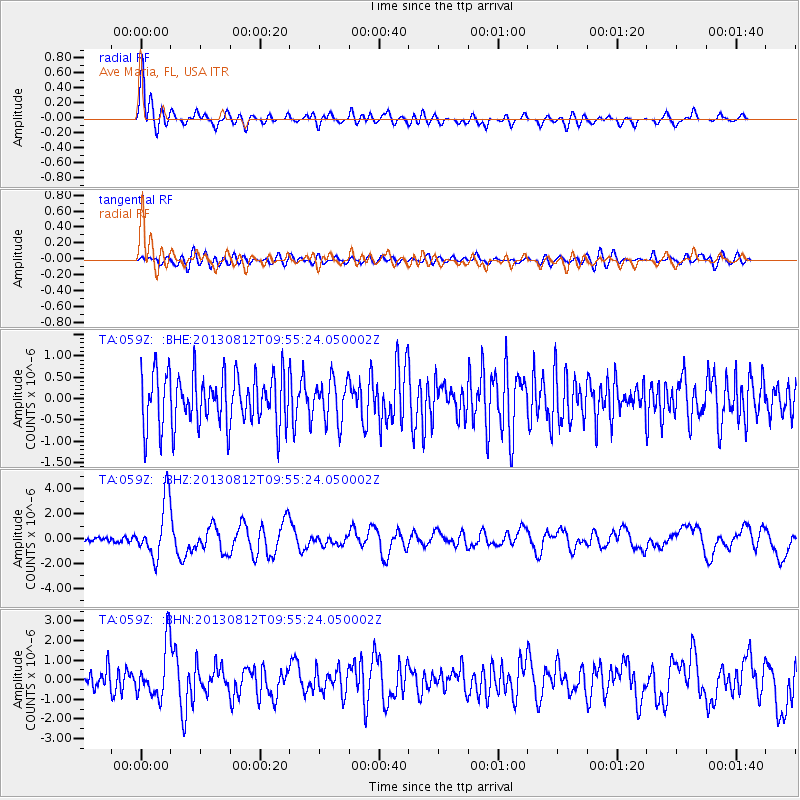
Earthquake location: Near Coast Of Northern Peru
Earthquake latitude/longitude: -5.4/-81.9
Earthquake time(UTC): 2013/08/12 (224) 09:49:32 GMT
Earthquake Depth: 10 km
Earthquake Magnitude: 6.2 MWW, 6.1 MWB, 6.2 MWW, 6.2 MWC, 6.3 MWC
Earthquake Catalog/Contributor: NEIC PDE/NEIC COMCAT
Network: TA USArray Transportable Network (new EarthScope stations)
Station: 059Z Ave Maria, FL, USA
Lat/Lon: 26.34 N/81.44 W
Elevation: 8.0 m
Distance: 31.5 deg
Az: 0.829 deg
Baz: 180.92 deg
Ray Param: 0.07903006
Estimated Moho Depth: 21.25 km
Estimated Crust Vp/Vs: 1.96
Assumed Crust Vp: 6.347 km/s
Estimated Crust Vs: 3.234 km/s
Estimated Crust Poisson's Ratio: 0.32
Radial Match: 83.46821 %
Radial Bump: 400
Transverse Match: 47.07746 %
Transverse Bump: 400
SOD ConfigId: 626651
Insert Time: 2014-04-17 23:17:27.572 +0000
GWidth: 2.5
Max Bumps: 400
Tol: 0.001

Signal To Noise

ChannelStoNSTALTA
TA:059Z: :BHZ:20130812T09:55:24.050002Z9.2154832.278443E-62.4724076E-7
TA:059Z: :BHN:20130812T09:55:24.050002Z2.73975131.326314E-64.8410016E-7
TA:059Z: :BHE:20130812T09:55:24.050002Z0.803119364.8567586E-76.047368E-7
Arrivals
Ps3.5 SECOND
PpPs9.2 SECOND
PsPs/PpSs13 SECOND