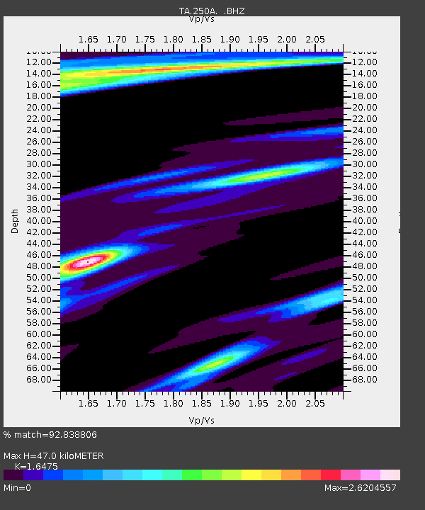
250A Grady, AL, USA - Earthquake Result Viewer

Earthquake location: Near Coast Of Northern Peru
Earthquake latitude/longitude: -5.4/-81.9
Earthquake time(UTC): 2013/08/12 (224) 09:49:32 GMT
Earthquake Depth: 10 km
Earthquake Magnitude: 6.2 MWW, 6.1 MWB, 6.2 MWW, 6.2 MWC, 6.3 MWC
Earthquake Catalog/Contributor: NEIC PDE/NEIC COMCAT
Network: TA USArray Transportable Network (new EarthScope stations)
Station: 250A Grady, AL, USA
Lat/Lon: 31.98 N/86.27 W
Elevation: 152 m
Distance: 37.4 deg
Az: 353.92 deg
Baz: 172.872 deg
Ray Param: 0.076159276
Estimated Moho Depth: 47.0 km
Estimated Crust Vp/Vs: 1.65
Assumed Crust Vp: 6.187 km/s
Estimated Crust Vs: 3.755 km/s
Estimated Crust Poisson's Ratio: 0.21
Radial Match: 92.838806 %
Radial Bump: 282
Transverse Match: 71.089005 %
Transverse Bump: 400
SOD ConfigId: 626651
Insert Time: 2014-04-17 23:18:25.965 +0000
GWidth: 2.5
Max Bumps: 400
Tol: 0.001

Signal To Noise

ChannelStoNSTALTA
TA:250A: :BHZ:20130812T09:56:14.500015Z26.2778432.8221766E-61.0739757E-7
TA:250A: :BHN:20130812T09:56:14.500015Z5.3167552.1276715E-64.0018233E-7
TA:250A: :BHE:20130812T09:56:14.500015Z1.16696868.1698244E-77.000895E-7
Arrivals
Ps5.3 SECOND
PpPs19 SECOND
PsPs/PpSs24 SECOND