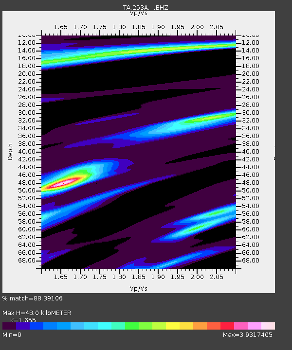
253A Americus, GA, USA - Earthquake Result Viewer
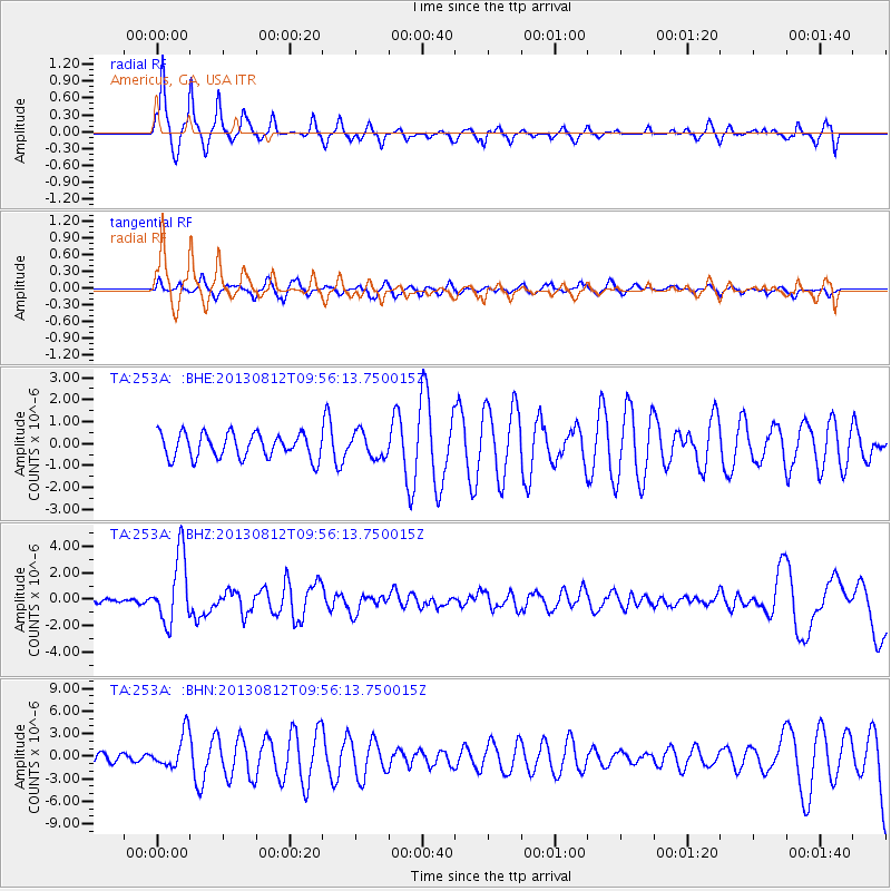
Earthquake location: Near Coast Of Northern Peru
Earthquake latitude/longitude: -5.4/-81.9
Earthquake time(UTC): 2013/08/12 (224) 09:49:32 GMT
Earthquake Depth: 10 km
Earthquake Magnitude: 6.2 MWW, 6.1 MWB, 6.2 MWW, 6.2 MWC, 6.3 MWC
Earthquake Catalog/Contributor: NEIC PDE/NEIC COMCAT
Network: TA USArray Transportable Network (new EarthScope stations)
Station: 253A Americus, GA, USA
Lat/Lon: 32.06 N/84.13 W
Elevation: 136 m
Distance: 37.3 deg
Az: 356.914 deg
Baz: 176.38 deg
Ray Param: 0.07620686
Estimated Moho Depth: 48.0 km
Estimated Crust Vp/Vs: 1.65
Assumed Crust Vp: 6.719 km/s
Estimated Crust Vs: 4.06 km/s
Estimated Crust Poisson's Ratio: 0.21
Radial Match: 88.39106 %
Radial Bump: 332
Transverse Match: 41.818977 %
Transverse Bump: 293
SOD ConfigId: 626651
Insert Time: 2014-04-17 23:18:38.288 +0000
GWidth: 2.5
Max Bumps: 400
Tol: 0.001

Signal To Noise

ChannelStoNSTALTA
TA:253A: :BHZ:20130812T09:56:13.750015Z22.5774882.5642348E-61.1357485E-7
TA:253A: :BHN:20130812T09:56:13.750015Z3.34839442.3076987E-66.891956E-7
TA:253A: :BHE:20130812T09:56:13.750015Z1.03197185.781494E-75.602376E-7
Arrivals
Ps5.1 SECOND
PpPs17 SECOND
PsPs/PpSs22 SECOND