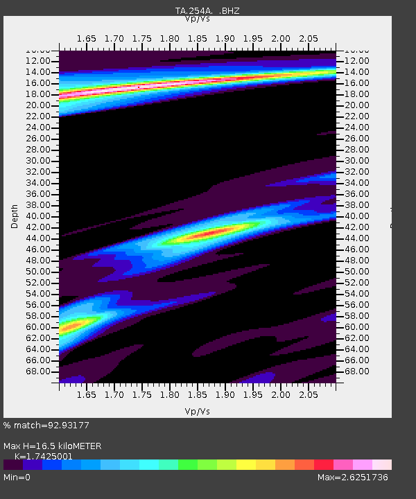
254A Abbeville, GA, USA - Earthquake Result Viewer
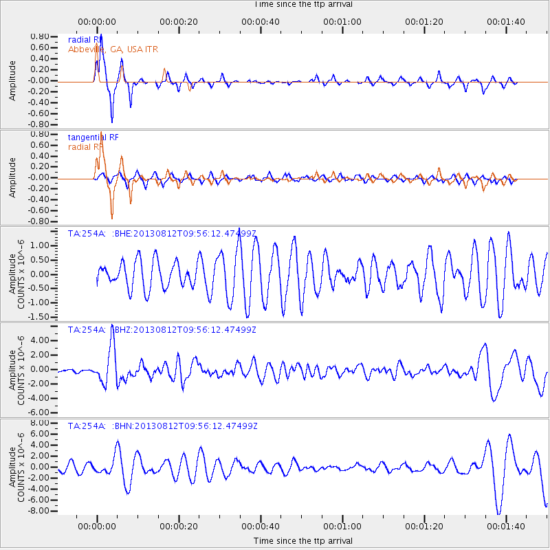
Earthquake location: Near Coast Of Northern Peru
Earthquake latitude/longitude: -5.4/-81.9
Earthquake time(UTC): 2013/08/12 (224) 09:49:32 GMT
Earthquake Depth: 10 km
Earthquake Magnitude: 6.2 MWW, 6.1 MWB, 6.2 MWW, 6.2 MWC, 6.3 MWC
Earthquake Catalog/Contributor: NEIC PDE/NEIC COMCAT
Network: TA USArray Transportable Network (new EarthScope stations)
Station: 254A Abbeville, GA, USA
Lat/Lon: 31.95 N/83.29 W
Elevation: 78 m
Distance: 37.2 deg
Az: 358.08 deg
Baz: 177.752 deg
Ray Param: 0.07628939
Estimated Moho Depth: 16.5 km
Estimated Crust Vp/Vs: 1.74
Assumed Crust Vp: 6.565 km/s
Estimated Crust Vs: 3.767 km/s
Estimated Crust Poisson's Ratio: 0.25
Radial Match: 92.93177 %
Radial Bump: 231
Transverse Match: 56.374084 %
Transverse Bump: 400
SOD ConfigId: 626651
Insert Time: 2014-04-17 23:18:44.093 +0000
GWidth: 2.5
Max Bumps: 400
Tol: 0.001

Signal To Noise

ChannelStoNSTALTA
TA:254A: :BHZ:20130812T09:56:12.47499Z16.5509532.7393337E-61.6550914E-7
TA:254A: :BHN:20130812T09:56:12.47499Z2.0111281.4380942E-67.1506844E-7
TA:254A: :BHE:20130812T09:56:12.47499Z1.9490558.600986E-74.412901E-7
Arrivals
Ps2.0 SECOND
PpPs6.4 SECOND
PsPs/PpSs8.4 SECOND