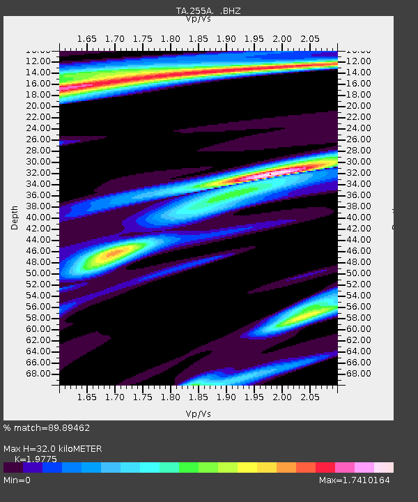
255A Hazlehurst, GA, USA - Earthquake Result Viewer
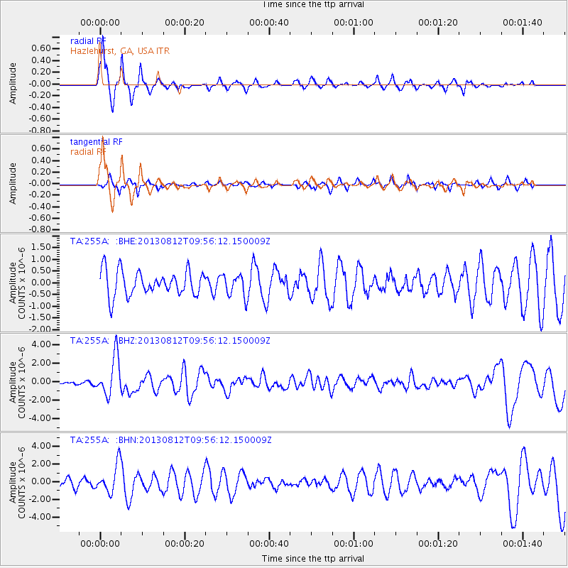
Earthquake location: Near Coast Of Northern Peru
Earthquake latitude/longitude: -5.4/-81.9
Earthquake time(UTC): 2013/08/12 (224) 09:49:32 GMT
Earthquake Depth: 10 km
Earthquake Magnitude: 6.2 MWW, 6.1 MWB, 6.2 MWW, 6.2 MWC, 6.3 MWC
Earthquake Catalog/Contributor: NEIC PDE/NEIC COMCAT
Network: TA USArray Transportable Network (new EarthScope stations)
Station: 255A Hazlehurst, GA, USA
Lat/Lon: 31.93 N/82.48 W
Elevation: 45 m
Distance: 37.1 deg
Az: 359.226 deg
Baz: 179.094 deg
Ray Param: 0.07631031
Estimated Moho Depth: 32.0 km
Estimated Crust Vp/Vs: 1.98
Assumed Crust Vp: 6.565 km/s
Estimated Crust Vs: 3.32 km/s
Estimated Crust Poisson's Ratio: 0.33
Radial Match: 89.89462 %
Radial Bump: 300
Transverse Match: 71.00217 %
Transverse Bump: 344
SOD ConfigId: 626651
Insert Time: 2014-04-17 23:18:45.418 +0000
GWidth: 2.5
Max Bumps: 400
Tol: 0.001

Signal To Noise

ChannelStoNSTALTA
TA:255A: :BHZ:20130812T09:56:12.150009Z10.4105642.1596127E-62.0744433E-7
TA:255A: :BHN:20130812T09:56:12.150009Z4.23923441.6827138E-63.9693813E-7
TA:255A: :BHE:20130812T09:56:12.150009Z0.91927154.836054E-75.2607464E-7
Arrivals
Ps5.1 SECOND
PpPs14 SECOND
PsPs/PpSs19 SECOND