You are here: Home > Network List > TA - USArray Transportable Network (new EarthScope stations) Stations List
> Station 257A Skidaway Island, Savannah, GA, USA > Earthquake Result Viewer
257A Skidaway Island, Savannah, GA, USA - Earthquake Result Viewer
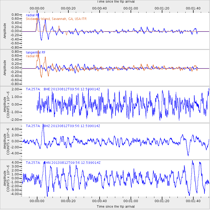
| Earthquake location: |
Near Coast Of Northern Peru |
| Earthquake latitude/longitude: |
-5.4/-81.9 |
| Earthquake time(UTC): |
2013/08/12 (224) 09:49:32 GMT |
| Earthquake Depth: |
10 km |
| Earthquake Magnitude: |
6.2 MWW, 6.1 MWB, 6.2 MWW, 6.2 MWC, 6.3 MWC |
| Earthquake Catalog/Contributor: |
NEIC PDE/NEIC COMCAT |
|
| Network: |
TA USArray Transportable Network (new EarthScope stations) |
| Station: |
257A Skidaway Island, Savannah, GA, USA |
| Lat/Lon: |
31.97 N/81.03 W |
| Elevation: |
9.0 m |
|
| Distance: |
37.2 deg |
| Az: |
1.267 deg |
| Baz: |
181.484 deg |
| Ray Param: |
0.07628068 |
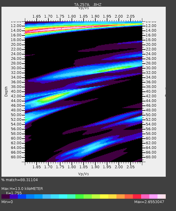
| Estimated Moho Depth: |
13.0 km |
| Estimated Crust Vp/Vs: |
1.75 |
| Assumed Crust Vp: |
5.989 km/s |
| Estimated Crust Vs: |
3.413 km/s |
| Estimated Crust Poisson's Ratio: |
0.26 |
|
| Radial Match: |
88.31104 % |
| Radial Bump: |
389 |
| Transverse Match: |
58.787388 % |
| Transverse Bump: |
400 |
| SOD ConfigId: |
626651 |
| Insert Time: |
2014-04-17 23:18:55.214 +0000 |
| GWidth: |
2.5 |
| Max Bumps: |
400 |
| Tol: |
0.001 |
|
Signal To Noise
| Channel | StoN | STA | LTA |
| TA:257A: :BHZ:20130812T09:56:12.599014Z | 6.8778653 | 2.3906234E-6 | 3.475822E-7 |
| TA:257A: :BHN:20130812T09:56:12.599014Z | 2.264567 | 1.8408554E-6 | 8.128951E-7 |
| TA:257A: :BHE:20130812T09:56:12.599014Z | 1.357615 | 9.020397E-7 | 6.644297E-7 |
| Arrivals |
| Ps | 1.7 SECOND |
| PpPs | 5.6 SECOND |
| PsPs/PpSs | 7.4 SECOND |


