You are here: Home > Network List > TA - USArray Transportable Network (new EarthScope stations) Stations List
> Station 355A Pearson, GA, USA > Earthquake Result Viewer
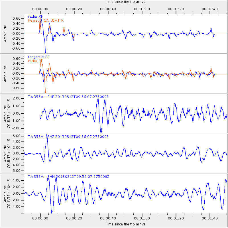
355A Pearson, GA, USA - Earthquake Result Viewer
*The percent match for this event was below the threshold and hence no stack was calculated.
| Earthquake location: |
Near Coast Of Northern Peru |
| Earthquake latitude/longitude: |
-5.4/-81.9 |
| Earthquake time(UTC): |
2013/08/12 (224) 09:49:32 GMT |
| Earthquake Depth: |
10 km |
| Earthquake Magnitude: |
6.2 MWW, 6.1 MWB, 6.2 MWW, 6.2 MWC, 6.3 MWC |
| Earthquake Catalog/Contributor: |
NEIC PDE/NEIC COMCAT |
|
| Network: |
TA USArray Transportable Network (new EarthScope stations) |
| Station: |
355A Pearson, GA, USA |
| Lat/Lon: |
31.34 N/82.85 W |
| Elevation: |
69 m |
|
| Distance: |
36.5 deg |
| Az: |
358.671 deg |
| Baz: |
178.453 deg |
| Ray Param: |
$rayparam |
*The percent match for this event was below the threshold and hence was not used in the summary stack. |
|
| Radial Match: |
92.57635 % |
| Radial Bump: |
285 |
| Transverse Match: |
78.07539 % |
| Transverse Bump: |
377 |
| SOD ConfigId: |
626651 |
| Insert Time: |
2014-04-17 23:19:08.159 +0000 |
| GWidth: |
2.5 |
| Max Bumps: |
400 |
| Tol: |
0.001 |
|
Signal To Noise
| Channel | StoN | STA | LTA |
| TA:355A: :BHZ:20130812T09:56:07.275009Z | 16.150423 | 2.8032323E-6 | 1.7357021E-7 |
| TA:355A: :BHN:20130812T09:56:07.275009Z | 7.0136647 | 2.0173745E-6 | 2.8763486E-7 |
| TA:355A: :BHE:20130812T09:56:07.275009Z | 2.7368608 | 9.267041E-7 | 3.386011E-7 |
| Arrivals |
| Ps | |
| PpPs | |
| PsPs/PpSs | |


