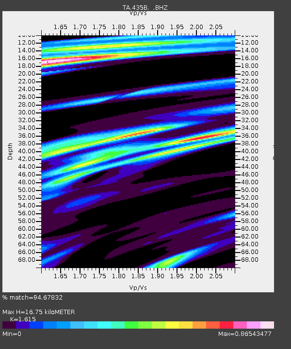
435B Jarrell, TX, USA - Earthquake Result Viewer

Earthquake location: Near Coast Of Northern Peru
Earthquake latitude/longitude: -5.4/-81.9
Earthquake time(UTC): 2013/08/12 (224) 09:49:32 GMT
Earthquake Depth: 10 km
Earthquake Magnitude: 6.2 MWW, 6.1 MWB, 6.2 MWW, 6.2 MWC, 6.3 MWC
Earthquake Catalog/Contributor: NEIC PDE/NEIC COMCAT
Network: TA USArray Transportable Network (new EarthScope stations)
Station: 435B Jarrell, TX, USA
Lat/Lon: 30.78 N/97.58 W
Elevation: 248 m
Distance: 39.0 deg
Az: 338.325 deg
Baz: 154.705 deg
Ray Param: 0.07525505
Estimated Moho Depth: 16.75 km
Estimated Crust Vp/Vs: 1.62
Assumed Crust Vp: 6.347 km/s
Estimated Crust Vs: 3.93 km/s
Estimated Crust Poisson's Ratio: 0.19
Radial Match: 94.67832 %
Radial Bump: 316
Transverse Match: 84.34031 %
Transverse Bump: 400
SOD ConfigId: 626651
Insert Time: 2014-04-17 23:19:13.277 +0000
GWidth: 2.5
Max Bumps: 400
Tol: 0.001

Signal To Noise

ChannelStoNSTALTA
TA:435B: :BHZ:20130812T09:56:27.750015Z28.8150842.042409E-67.087986E-8
TA:435B: :BHN:20130812T09:56:27.750015Z11.3861889.3580474E-78.218772E-8
TA:435B: :BHE:20130812T09:56:27.750015Z2.42767383.9011184E-71.6069369E-7
Arrivals
Ps1.8 SECOND
PpPs6.4 SECOND
PsPs/PpSs8.1 SECOND