455A Stateville, GA, USA - Earthquake Result Viewer
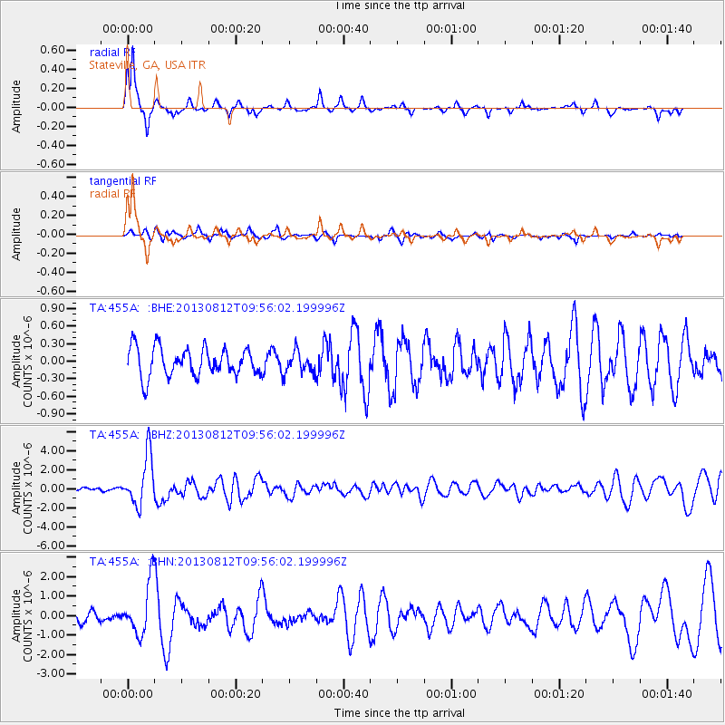
Earthquake location: Near Coast Of Northern Peru
Earthquake latitude/longitude: -5.4/-81.9
Earthquake time(UTC): 2013/08/12 (224) 09:49:32 GMT
Earthquake Depth: 10 km
Earthquake Magnitude: 6.2 MWW, 6.1 MWB, 6.2 MWW, 6.2 MWC, 6.3 MWC
Earthquake Catalog/Contributor: NEIC PDE/NEIC COMCAT
Network: TA USArray Transportable Network (new EarthScope stations)
Station: 455A Stateville, GA, USA
Lat/Lon: 30.74 N/83.03 W
Elevation: 44 m
Distance: 35.9 deg
Az: 358.388 deg
Baz: 178.136 deg
Ray Param: 0.076946974
Estimated Moho Depth: 18.75 km
Estimated Crust Vp/Vs: 1.60
Assumed Crust Vp: 6.565 km/s
Estimated Crust Vs: 4.096 km/s
Estimated Crust Poisson's Ratio: 0.18
Radial Match: 85.97284 %
Radial Bump: 245
Transverse Match: 57.919586 %
Transverse Bump: 383
SOD ConfigId: 626651
Insert Time: 2014-04-17 23:19:39.361 +0000
GWidth: 2.5
Max Bumps: 400
Tol: 0.001

Signal To Noise

ChannelStoNSTALTA
TA:455A: :BHZ:20130812T09:56:02.199996Z12.0559622.6455134E-62.1943612E-7
TA:455A: :BHN:20130812T09:56:02.199996Z5.7007961.3671103E-62.3981042E-7
TA:455A: :BHE:20130812T09:56:02.199996Z0.711265271.7264193E-72.4272512E-7
Arrivals
Ps1.9 SECOND
PpPs6.8 SECOND
PsPs/PpSs8.7 SECOND