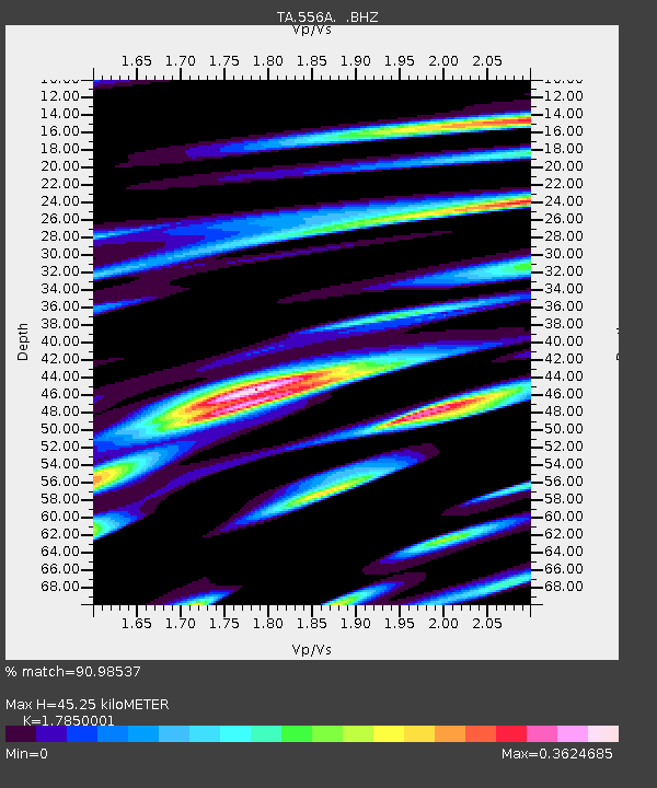
556A Lake Butler, FL, USA - Earthquake Result Viewer

Earthquake location: Near Coast Of Northern Peru
Earthquake latitude/longitude: -5.4/-81.9
Earthquake time(UTC): 2013/08/12 (224) 09:49:32 GMT
Earthquake Depth: 10 km
Earthquake Magnitude: 6.2 MWW, 6.1 MWB, 6.2 MWW, 6.2 MWC, 6.3 MWC
Earthquake Catalog/Contributor: NEIC PDE/NEIC COMCAT
Network: TA USArray Transportable Network (new EarthScope stations)
Station: 556A Lake Butler, FL, USA
Lat/Lon: 30.00 N/82.41 W
Elevation: 45 m
Distance: 35.2 deg
Az: 359.279 deg
Baz: 179.173 deg
Ray Param: 0.07734852
Estimated Moho Depth: 45.25 km
Estimated Crust Vp/Vs: 1.79
Assumed Crust Vp: 6.565 km/s
Estimated Crust Vs: 3.678 km/s
Estimated Crust Poisson's Ratio: 0.27
Radial Match: 90.98537 %
Radial Bump: 299
Transverse Match: 70.315056 %
Transverse Bump: 400
SOD ConfigId: 626651
Insert Time: 2014-04-17 23:20:14.486 +0000
GWidth: 2.5
Max Bumps: 400
Tol: 0.001

Signal To Noise

ChannelStoNSTALTA
TA:556A: :BHZ:20130812T09:55:55.774001Z19.3792292.0354817E-61.0503419E-7
TA:556A: :BHN:20130812T09:55:55.774001Z14.530611.5685304E-61.0794663E-7
TA:556A: :BHE:20130812T09:55:55.774001Z2.25785762.8712444E-71.2716677E-7
Arrivals
Ps5.9 SECOND
PpPs18 SECOND
PsPs/PpSs24 SECOND