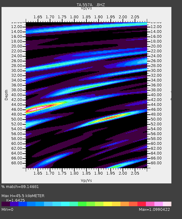
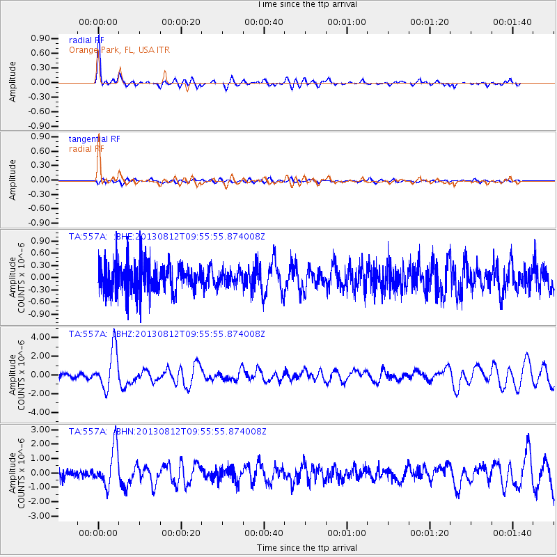
557A Orange Park, FL, USA - Earthquake Result Viewer

Earthquake location: Near Coast Of Northern Peru
Earthquake latitude/longitude: -5.4/-81.9
Earthquake time(UTC): 2013/08/12 (224) 09:49:32 GMT
Earthquake Depth: 10 km
Earthquake Magnitude: 6.2 MWW, 6.1 MWB, 6.2 MWW, 6.2 MWC, 6.3 MWC
Earthquake Catalog/Contributor: NEIC PDE/NEIC COMCAT
Network: TA USArray Transportable Network (new EarthScope stations)
Station: 557A Orange Park, FL, USA
Lat/Lon: 30.02 N/81.73 W
Elevation: 24 m
Distance: 35.2 deg
Az: 0.297 deg
Baz: 180.341 deg
Ray Param: 0.07734233
Estimated Moho Depth: 45.5 km
Estimated Crust Vp/Vs: 1.64
Assumed Crust Vp: 5.989 km/s
Estimated Crust Vs: 3.646 km/s
Estimated Crust Poisson's Ratio: 0.21
Radial Match: 89.14681 %
Radial Bump: 400
Transverse Match: 47.09587 %
Transverse Bump: 400
SOD ConfigId: 626651
Insert Time: 2014-04-17 23:20:22.124 +0000
GWidth: 2.5
Max Bumps: 400
Tol: 0.001

Signal To Noise

ChannelStoNSTALTA
TA:557A: :BHZ:20130812T09:55:55.874008Z7.88394552.1952758E-62.7844888E-7
TA:557A: :BHN:20130812T09:55:55.874008Z3.90916821.3820663E-63.5354486E-7
TA:557A: :BHE:20130812T09:55:55.874008Z0.48196911.7183507E-73.5652718E-7
Arrivals
Ps5.2 SECOND
PpPs19 SECOND
PsPs/PpSs24 SECOND