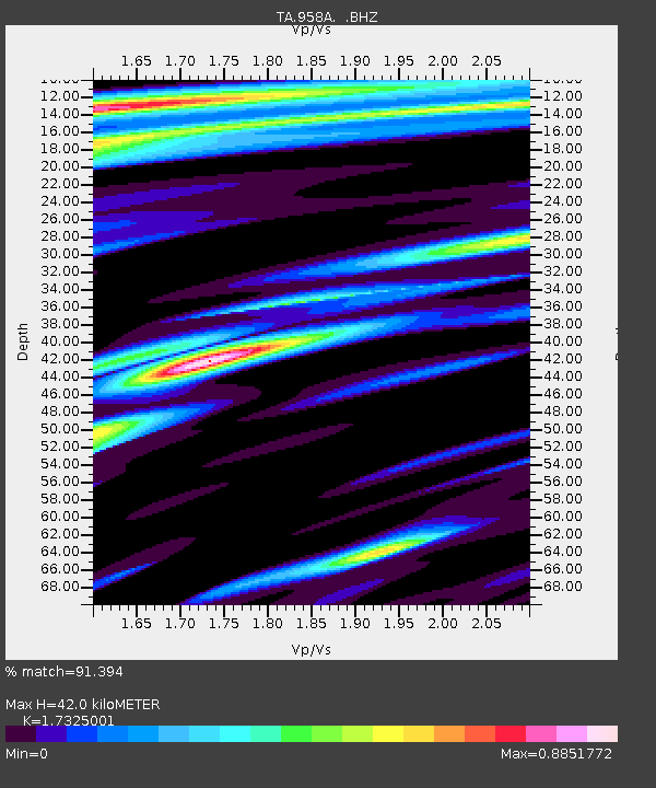
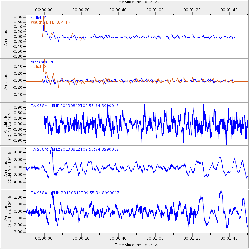
958A Wauchula, FL, USA - Earthquake Result Viewer

Earthquake location: Near Coast Of Northern Peru
Earthquake latitude/longitude: -5.4/-81.9
Earthquake time(UTC): 2013/08/12 (224) 09:49:32 GMT
Earthquake Depth: 10 km
Earthquake Magnitude: 6.2 MWW, 6.1 MWB, 6.2 MWW, 6.2 MWC, 6.3 MWC
Earthquake Catalog/Contributor: NEIC PDE/NEIC COMCAT
Network: TA USArray Transportable Network (new EarthScope stations)
Station: 958A Wauchula, FL, USA
Lat/Lon: 27.59 N/81.75 W
Elevation: 30 m
Distance: 32.8 deg
Az: 0.283 deg
Baz: 180.317 deg
Ray Param: 0.078502655
Estimated Moho Depth: 42.0 km
Estimated Crust Vp/Vs: 1.73
Assumed Crust Vp: 6.347 km/s
Estimated Crust Vs: 3.664 km/s
Estimated Crust Poisson's Ratio: 0.25
Radial Match: 91.394 %
Radial Bump: 400
Transverse Match: 63.069233 %
Transverse Bump: 400
SOD ConfigId: 626651
Insert Time: 2014-04-17 23:21:07.034 +0000
GWidth: 2.5
Max Bumps: 400
Tol: 0.001

Signal To Noise

ChannelStoNSTALTA
TA:958A: :BHZ:20130812T09:55:34.899001Z9.6854522.5097165E-62.591223E-7
TA:958A: :BHN:20130812T09:55:34.899001Z5.2704531.2767861E-62.4225358E-7
TA:958A: :BHE:20130812T09:55:34.899001Z1.35912853.4629332E-72.547907E-7
Arrivals
Ps5.2 SECOND
PpPs17 SECOND
PsPs/PpSs22 SECOND