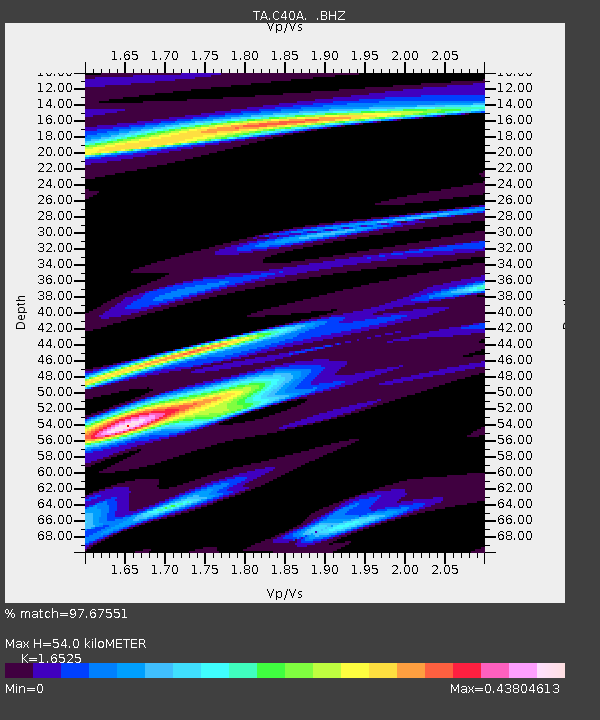
C40A Isle Royale National Park, MI, USA - Earthquake Result Viewer
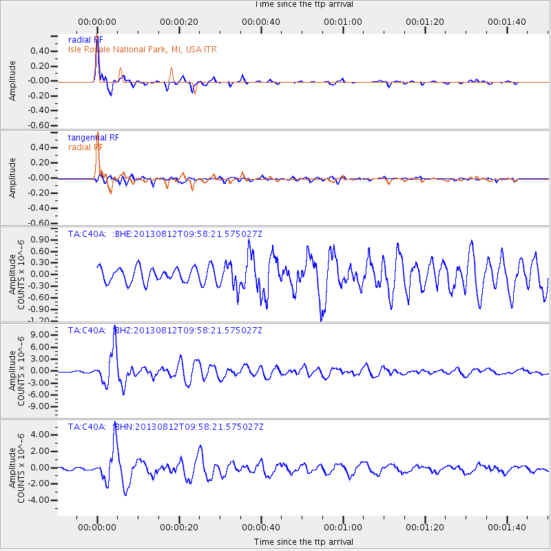
Earthquake location: Near Coast Of Northern Peru
Earthquake latitude/longitude: -5.4/-81.9
Earthquake time(UTC): 2013/08/12 (224) 09:49:32 GMT
Earthquake Depth: 10 km
Earthquake Magnitude: 6.2 MWW, 6.1 MWB, 6.2 MWW, 6.2 MWC, 6.3 MWC
Earthquake Catalog/Contributor: NEIC PDE/NEIC COMCAT
Network: TA USArray Transportable Network (new EarthScope stations)
Station: C40A Isle Royale National Park, MI, USA
Lat/Lon: 47.92 N/89.15 W
Elevation: 216 m
Distance: 53.5 deg
Az: 353.956 deg
Baz: 171.035 deg
Ray Param: 0.06608237
Estimated Moho Depth: 54.0 km
Estimated Crust Vp/Vs: 1.65
Assumed Crust Vp: 6.467 km/s
Estimated Crust Vs: 3.913 km/s
Estimated Crust Poisson's Ratio: 0.21
Radial Match: 97.67551 %
Radial Bump: 336
Transverse Match: 61.59459 %
Transverse Bump: 400
SOD ConfigId: 626651
Insert Time: 2014-04-17 23:21:36.479 +0000
GWidth: 2.5
Max Bumps: 400
Tol: 0.001

Signal To Noise

ChannelStoNSTALTA
TA:C40A: :BHZ:20130812T09:58:21.575027Z23.537524.5326965E-61.9257325E-7
TA:C40A: :BHN:20130812T09:58:21.575027Z15.8736012.206419E-61.3899927E-7
TA:C40A: :BHE:20130812T09:58:21.575027Z1.74897193.1094822E-71.7778913E-7
Arrivals
Ps5.8 SECOND
PpPs21 SECOND
PsPs/PpSs27 SECOND