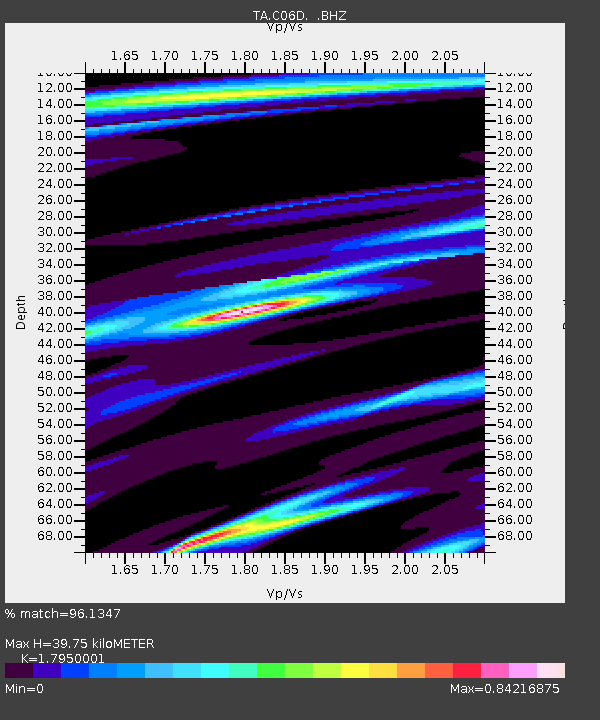
C06D Leavenworth, WQ, USA - Earthquake Result Viewer
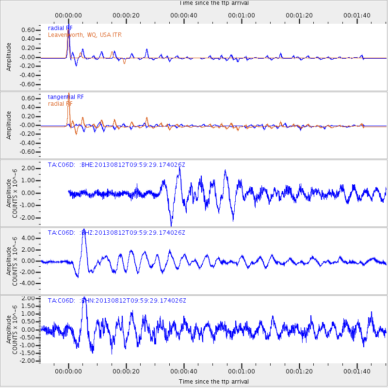
Earthquake location: Near Coast Of Northern Peru
Earthquake latitude/longitude: -5.4/-81.9
Earthquake time(UTC): 2013/08/12 (224) 09:49:32 GMT
Earthquake Depth: 10 km
Earthquake Magnitude: 6.2 MWW, 6.1 MWB, 6.2 MWW, 6.2 MWC, 6.3 MWC
Earthquake Catalog/Contributor: NEIC PDE/NEIC COMCAT
Network: TA USArray Transportable Network (new EarthScope stations)
Station: C06D Leavenworth, WQ, USA
Lat/Lon: 47.92 N/120.89 W
Elevation: 544 m
Distance: 63.2 deg
Az: 331.701 deg
Baz: 135.433 deg
Ray Param: 0.059758544
Estimated Moho Depth: 39.75 km
Estimated Crust Vp/Vs: 1.80
Assumed Crust Vp: 6.597 km/s
Estimated Crust Vs: 3.675 km/s
Estimated Crust Poisson's Ratio: 0.27
Radial Match: 96.1347 %
Radial Bump: 280
Transverse Match: 87.01899 %
Transverse Bump: 400
SOD ConfigId: 626651
Insert Time: 2014-04-17 23:21:39.533 +0000
GWidth: 2.5
Max Bumps: 400
Tol: 0.001

Signal To Noise

ChannelStoNSTALTA
TA:C06D: :BHZ:20130812T09:59:29.174026Z13.9921641.466124E-61.0478179E-7
TA:C06D: :BHN:20130812T09:59:29.174026Z3.23966485.511597E-71.7012862E-7
TA:C06D: :BHE:20130812T09:59:29.174026Z3.15731535.417341E-71.7158061E-7
Arrivals
Ps5.0 SECOND
PpPs16 SECOND
PsPs/PpSs21 SECOND