You are here: Home > Network List > TA - USArray Transportable Network (new EarthScope stations) Stations List
> Station E43A Lone Tree Farm, Eben Junction, MI, USA > Earthquake Result Viewer
E43A Lone Tree Farm, Eben Junction, MI, USA - Earthquake Result Viewer
| Earthquake location: |
Near Coast Of Northern Peru |
| Earthquake latitude/longitude: |
-5.4/-81.9 |
| Earthquake time(UTC): |
2013/08/12 (224) 09:49:32 GMT |
| Earthquake Depth: |
10 km |
| Earthquake Magnitude: |
6.2 MWW, 6.1 MWB, 6.2 MWW, 6.2 MWC, 6.3 MWC |
| Earthquake Catalog/Contributor: |
NEIC PDE/NEIC COMCAT |
|
| Network: |
TA USArray Transportable Network (new EarthScope stations) |
| Station: |
E43A Lone Tree Farm, Eben Junction, MI, USA |
| Lat/Lon: |
46.38 N/87.00 W |
| Elevation: |
303 m |
|
| Distance: |
51.7 deg |
| Az: |
355.532 deg |
| Baz: |
173.568 deg |
| Ray Param: |
0.06721525 |
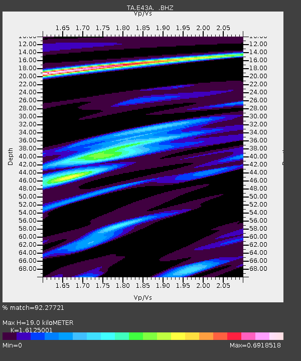
| Estimated Moho Depth: |
19.0 km |
| Estimated Crust Vp/Vs: |
1.61 |
| Assumed Crust Vp: |
6.472 km/s |
| Estimated Crust Vs: |
4.014 km/s |
| Estimated Crust Poisson's Ratio: |
0.19 |
|
| Radial Match: |
92.27721 % |
| Radial Bump: |
246 |
| Transverse Match: |
70.094475 % |
| Transverse Bump: |
400 |
| SOD ConfigId: |
626651 |
| Insert Time: |
2014-04-17 23:22:57.108 +0000 |
| GWidth: |
2.5 |
| Max Bumps: |
400 |
| Tol: |
0.001 |
|
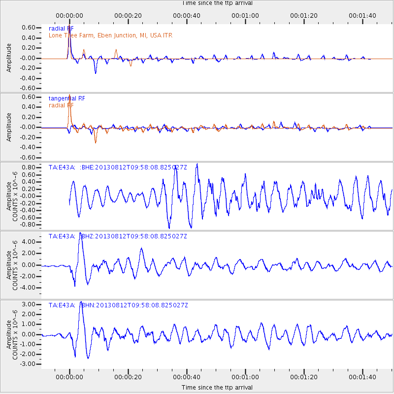
Signal To Noise
| Channel | StoN | STA | LTA |
| TA:E43A: :BHZ:20130812T09:58:08.825027Z | 10.318964 | 2.7713625E-6 | 2.685698E-7 |
| TA:E43A: :BHN:20130812T09:58:08.825027Z | 8.005229 | 1.6332507E-6 | 2.0402298E-7 |
| TA:E43A: :BHE:20130812T09:58:08.825027Z | 2.0096526 | 4.0695667E-7 | 2.02501E-7 |
| Arrivals |
| Ps | 1.9 SECOND |
| PpPs | 7.2 SECOND |
| PsPs/PpSs | 9.1 SECOND |


