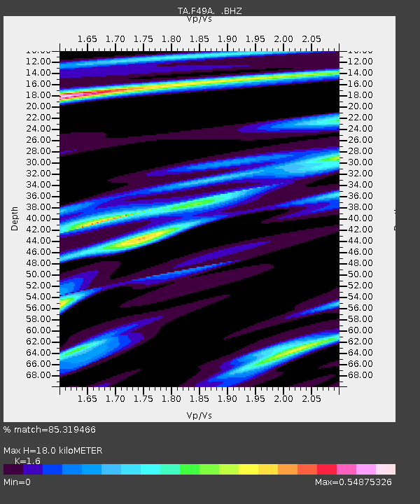
F49A Sandfield, ON, CAN - Earthquake Result Viewer
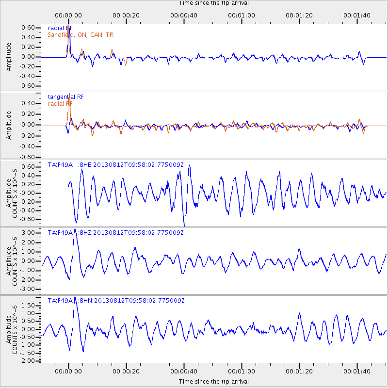
Earthquake location: Near Coast Of Northern Peru
Earthquake latitude/longitude: -5.4/-81.9
Earthquake time(UTC): 2013/08/12 (224) 09:49:32 GMT
Earthquake Depth: 10 km
Earthquake Magnitude: 6.2 MWW, 6.1 MWB, 6.2 MWW, 6.2 MWC, 6.3 MWC
Earthquake Catalog/Contributor: NEIC PDE/NEIC COMCAT
Network: TA USArray Transportable Network (new EarthScope stations)
Station: F49A Sandfield, ON, CAN
Lat/Lon: 45.76 N/82.04 W
Elevation: 230 m
Distance: 50.9 deg
Az: 359.896 deg
Baz: 179.852 deg
Ray Param: 0.067730956
Estimated Moho Depth: 18.0 km
Estimated Crust Vp/Vs: 1.60
Assumed Crust Vp: 6.483 km/s
Estimated Crust Vs: 4.052 km/s
Estimated Crust Poisson's Ratio: 0.18
Radial Match: 85.319466 %
Radial Bump: 350
Transverse Match: 55.04587 %
Transverse Bump: 400
SOD ConfigId: 626651
Insert Time: 2014-04-17 23:24:34.412 +0000
GWidth: 2.5
Max Bumps: 400
Tol: 0.001

Signal To Noise

ChannelStoNSTALTA
TA:F49A: :BHZ:20130812T09:58:02.775009Z4.8447391.8084803E-63.732875E-7
TA:F49A: :BHN:20130812T09:58:02.775009Z3.58259581.0752157E-63.0012194E-7
TA:F49A: :BHE:20130812T09:58:02.775009Z0.456703341.2228624E-72.6775857E-7
Arrivals
Ps1.8 SECOND
PpPs6.8 SECOND
PsPs/PpSs8.5 SECOND