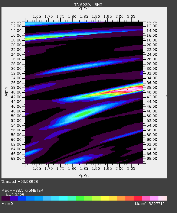
G03D McMinnville, OR, USA - Earthquake Result Viewer
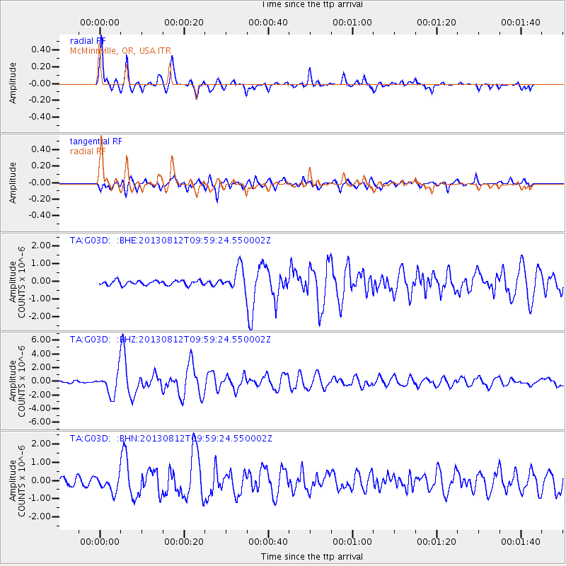
Earthquake location: Near Coast Of Northern Peru
Earthquake latitude/longitude: -5.4/-81.9
Earthquake time(UTC): 2013/08/12 (224) 09:49:32 GMT
Earthquake Depth: 10 km
Earthquake Magnitude: 6.2 MWW, 6.1 MWB, 6.2 MWW, 6.2 MWC, 6.3 MWC
Earthquake Catalog/Contributor: NEIC PDE/NEIC COMCAT
Network: TA USArray Transportable Network (new EarthScope stations)
Station: G03D McMinnville, OR, USA
Lat/Lon: 45.21 N/123.26 W
Elevation: 222 m
Distance: 62.5 deg
Az: 328.228 deg
Baz: 132.13 deg
Ray Param: 0.060210582
Estimated Moho Depth: 38.5 km
Estimated Crust Vp/Vs: 2.03
Assumed Crust Vp: 6.566 km/s
Estimated Crust Vs: 3.231 km/s
Estimated Crust Poisson's Ratio: 0.34
Radial Match: 93.98928 %
Radial Bump: 378
Transverse Match: 79.78707 %
Transverse Bump: 400
SOD ConfigId: 626651
Insert Time: 2014-04-17 23:25:10.764 +0000
GWidth: 2.5
Max Bumps: 400
Tol: 0.001

Signal To Noise

ChannelStoNSTALTA
TA:G03D: :BHZ:20130812T09:59:24.550002Z15.4439191.7585154E-61.1386458E-7
TA:G03D: :BHN:20130812T09:59:24.550002Z2.53583674.5304517E-71.7865707E-7
TA:G03D: :BHE:20130812T09:59:24.550002Z5.46840056.736177E-71.2318368E-7
Arrivals
Ps6.3 SECOND
PpPs17 SECOND
PsPs/PpSs23 SECOND