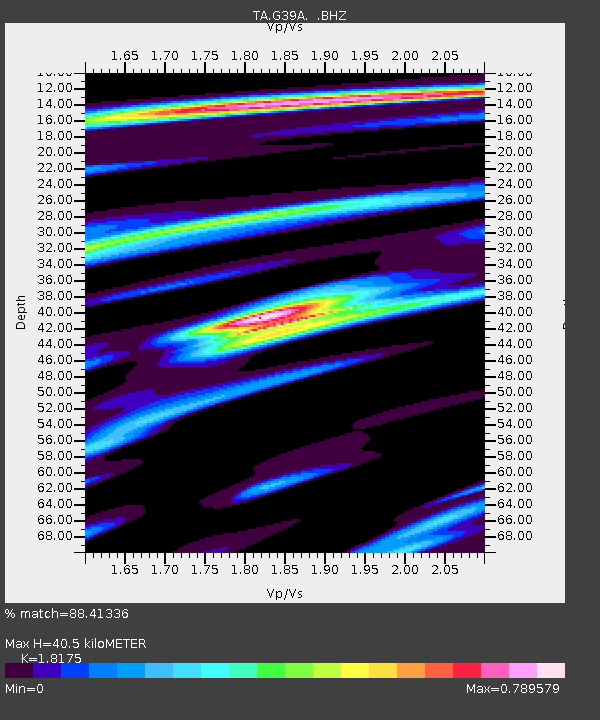
G39A Holcombe, WI, USA - Earthquake Result Viewer

Earthquake location: Near Coast Of Northern Peru
Earthquake latitude/longitude: -5.4/-81.9
Earthquake time(UTC): 2013/08/12 (224) 09:49:32 GMT
Earthquake Depth: 10 km
Earthquake Magnitude: 6.2 MWW, 6.1 MWB, 6.2 MWW, 6.2 MWC, 6.3 MWC
Earthquake Catalog/Contributor: NEIC PDE/NEIC COMCAT
Network: TA USArray Transportable Network (new EarthScope stations)
Station: G39A Holcombe, WI, USA
Lat/Lon: 45.29 N/91.17 W
Elevation: 350 m
Distance: 51.1 deg
Az: 351.626 deg
Baz: 168.147 deg
Ray Param: 0.0676071
Estimated Moho Depth: 40.5 km
Estimated Crust Vp/Vs: 1.82
Assumed Crust Vp: 6.571 km/s
Estimated Crust Vs: 3.615 km/s
Estimated Crust Poisson's Ratio: 0.28
Radial Match: 88.41336 %
Radial Bump: 331
Transverse Match: 75.03792 %
Transverse Bump: 400
SOD ConfigId: 626651
Insert Time: 2014-04-17 23:25:14.266 +0000
GWidth: 2.5
Max Bumps: 400
Tol: 0.001

Signal To Noise

ChannelStoNSTALTA
TA:G39A: :BHZ:20130812T09:58:04.250015Z8.4234593.2506669E-63.8590642E-7
TA:G39A: :BHN:20130812T09:58:04.250015Z5.36468271.8527297E-63.4535682E-7
TA:G39A: :BHE:20130812T09:58:04.250015Z3.7548955.20107E-71.385144E-7
Arrivals
Ps5.3 SECOND
PpPs16 SECOND
PsPs/PpSs22 SECOND