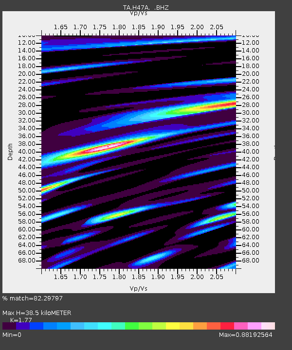
H47A Mio, MI, USA - Earthquake Result Viewer
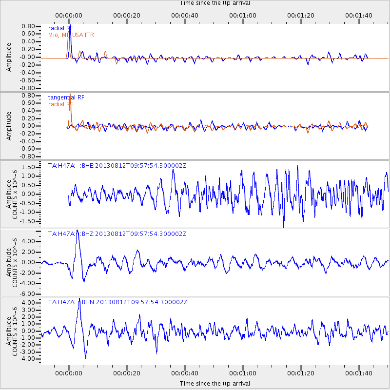
Earthquake location: Near Coast Of Northern Peru
Earthquake latitude/longitude: -5.4/-81.9
Earthquake time(UTC): 2013/08/12 (224) 09:49:32 GMT
Earthquake Depth: 10 km
Earthquake Magnitude: 6.2 MWW, 6.1 MWB, 6.2 MWW, 6.2 MWC, 6.3 MWC
Earthquake Catalog/Contributor: NEIC PDE/NEIC COMCAT
Network: TA USArray Transportable Network (new EarthScope stations)
Station: H47A Mio, MI, USA
Lat/Lon: 44.60 N/84.21 W
Elevation: 356 m
Distance: 49.8 deg
Az: 357.868 deg
Baz: 177.029 deg
Ray Param: 0.068464205
Estimated Moho Depth: 38.5 km
Estimated Crust Vp/Vs: 1.77
Assumed Crust Vp: 6.483 km/s
Estimated Crust Vs: 3.662 km/s
Estimated Crust Poisson's Ratio: 0.27
Radial Match: 82.29797 %
Radial Bump: 400
Transverse Match: 65.26185 %
Transverse Bump: 400
SOD ConfigId: 626651
Insert Time: 2014-04-17 23:26:08.452 +0000
GWidth: 2.5
Max Bumps: 400
Tol: 0.001

Signal To Noise

ChannelStoNSTALTA
TA:H47A: :BHZ:20130812T09:57:54.300002Z9.7473322.8673608E-62.9416879E-7
TA:H47A: :BHN:20130812T09:57:54.300002Z3.75229791.9763343E-65.266997E-7
TA:H47A: :BHE:20130812T09:57:54.300002Z2.65166456.273396E-72.3658332E-7
Arrivals
Ps4.9 SECOND
PpPs15 SECOND
PsPs/PpSs20 SECOND