You are here: Home > Network List > TA - USArray Transportable Network (new EarthScope stations) Stations List
> Station I04A Tendick Farm, Oakridge, OR, USA > Earthquake Result Viewer
I04A Tendick Farm, Oakridge, OR, USA - Earthquake Result Viewer
| Earthquake location: |
Near Coast Of Northern Peru |
| Earthquake latitude/longitude: |
-5.4/-81.9 |
| Earthquake time(UTC): |
2013/08/12 (224) 09:49:32 GMT |
| Earthquake Depth: |
10 km |
| Earthquake Magnitude: |
6.2 MWW, 6.1 MWB, 6.2 MWW, 6.2 MWC, 6.3 MWC |
| Earthquake Catalog/Contributor: |
NEIC PDE/NEIC COMCAT |
|
| Network: |
TA USArray Transportable Network (new EarthScope stations) |
| Station: |
I04A Tendick Farm, Oakridge, OR, USA |
| Lat/Lon: |
43.79 N/122.41 W |
| Elevation: |
731 m |
|
| Distance: |
61.1 deg |
| Az: |
327.503 deg |
| Baz: |
132.382 deg |
| Ray Param: |
0.061123226 |
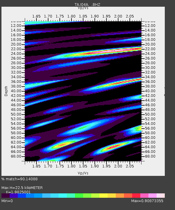
| Estimated Moho Depth: |
22.5 km |
| Estimated Crust Vp/Vs: |
1.98 |
| Assumed Crust Vp: |
6.522 km/s |
| Estimated Crust Vs: |
3.29 km/s |
| Estimated Crust Poisson's Ratio: |
0.33 |
|
| Radial Match: |
90.14088 % |
| Radial Bump: |
400 |
| Transverse Match: |
80.056526 % |
| Transverse Bump: |
400 |
| SOD ConfigId: |
626651 |
| Insert Time: |
2014-04-17 23:26:32.475 +0000 |
| GWidth: |
2.5 |
| Max Bumps: |
400 |
| Tol: |
0.001 |
|
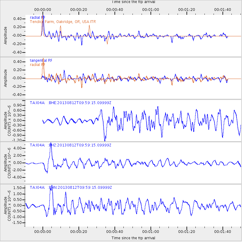
Signal To Noise
| Channel | StoN | STA | LTA |
| TA:I04A: :BHZ:20130812T09:59:15.09999Z | 25.903769 | 2.304921E-6 | 8.898014E-8 |
| TA:I04A: :BHN:20130812T09:59:15.09999Z | 4.9950423 | 6.840917E-7 | 1.3695414E-7 |
| TA:I04A: :BHE:20130812T09:59:15.09999Z | 4.9094763 | 5.138948E-7 | 1.0467406E-7 |
| Arrivals |
| Ps | 3.5 SECOND |
| PpPs | 9.9 SECOND |
| PsPs/PpSs | 13 SECOND |


