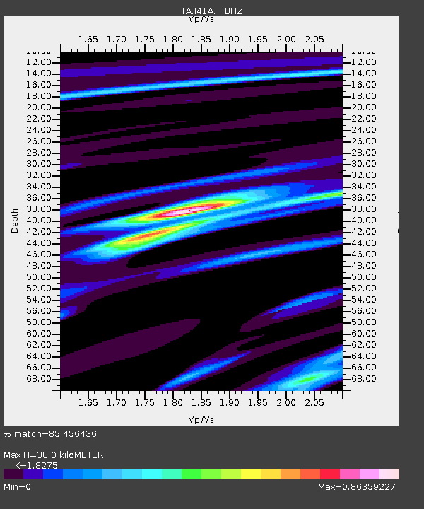
I41A Arkdale, WI, USA - Earthquake Result Viewer
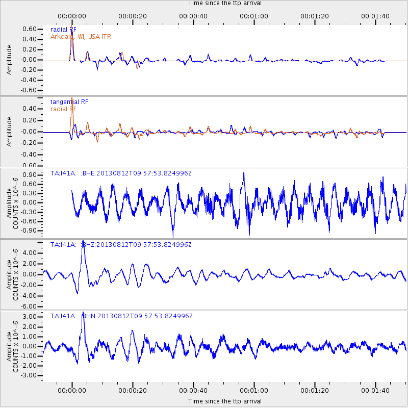
Earthquake location: Near Coast Of Northern Peru
Earthquake latitude/longitude: -5.4/-81.9
Earthquake time(UTC): 2013/08/12 (224) 09:49:32 GMT
Earthquake Depth: 10 km
Earthquake Magnitude: 6.2 MWW, 6.1 MWB, 6.2 MWW, 6.2 MWC, 6.3 MWC
Earthquake Catalog/Contributor: NEIC PDE/NEIC COMCAT
Network: TA USArray Transportable Network (new EarthScope stations)
Station: I41A Arkdale, WI, USA
Lat/Lon: 44.06 N/89.87 W
Elevation: 289 m
Distance: 49.7 deg
Az: 352.499 deg
Baz: 169.614 deg
Ray Param: 0.068504475
Estimated Moho Depth: 38.0 km
Estimated Crust Vp/Vs: 1.83
Assumed Crust Vp: 6.41 km/s
Estimated Crust Vs: 3.508 km/s
Estimated Crust Poisson's Ratio: 0.29
Radial Match: 85.456436 %
Radial Bump: 256
Transverse Match: 75.57564 %
Transverse Bump: 400
SOD ConfigId: 626651
Insert Time: 2014-04-17 23:26:38.688 +0000
GWidth: 2.5
Max Bumps: 400
Tol: 0.001

Signal To Noise

ChannelStoNSTALTA
TA:I41A: :BHZ:20130812T09:57:53.824996Z4.88648842.8575762E-65.8479134E-7
TA:I41A: :BHN:20130812T09:57:53.824996Z3.37171771.4807277E-64.3916125E-7
TA:I41A: :BHE:20130812T09:57:53.824996Z1.5254714.283845E-72.8082115E-7
Arrivals
Ps5.2 SECOND
PpPs16 SECOND
PsPs/PpSs21 SECOND