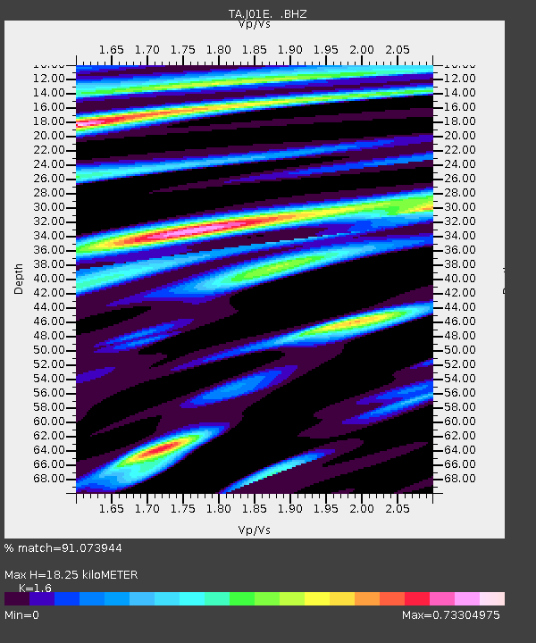
J01E Myrtle Point, OR, USA - Earthquake Result Viewer
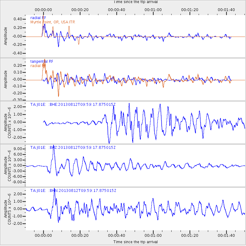
Earthquake location: Near Coast Of Northern Peru
Earthquake latitude/longitude: -5.4/-81.9
Earthquake time(UTC): 2013/08/12 (224) 09:49:32 GMT
Earthquake Depth: 10 km
Earthquake Magnitude: 6.2 MWW, 6.1 MWB, 6.2 MWW, 6.2 MWC, 6.3 MWC
Earthquake Catalog/Contributor: NEIC PDE/NEIC COMCAT
Network: TA USArray Transportable Network (new EarthScope stations)
Station: J01E Myrtle Point, OR, USA
Lat/Lon: 43.16 N/123.93 W
Elevation: 128 m
Distance: 61.5 deg
Az: 326.127 deg
Baz: 130.678 deg
Ray Param: 0.06085533
Estimated Moho Depth: 18.25 km
Estimated Crust Vp/Vs: 1.60
Assumed Crust Vp: 6.522 km/s
Estimated Crust Vs: 4.076 km/s
Estimated Crust Poisson's Ratio: 0.18
Radial Match: 91.073944 %
Radial Bump: 400
Transverse Match: 88.38973 %
Transverse Bump: 400
SOD ConfigId: 626651
Insert Time: 2014-04-17 23:27:14.180 +0000
GWidth: 2.5
Max Bumps: 400
Tol: 0.001

Signal To Noise

ChannelStoNSTALTA
TA:J01E: :BHZ:20130812T09:59:17.875015Z12.3802081.9469435E-61.5726259E-7
TA:J01E: :BHN:20130812T09:59:17.875015Z2.9747924.3384043E-71.4583891E-7
TA:J01E: :BHE:20130812T09:59:17.875015Z4.33032944.8348124E-71.1164999E-7
Arrivals
Ps1.8 SECOND
PpPs6.9 SECOND
PsPs/PpSs8.7 SECOND