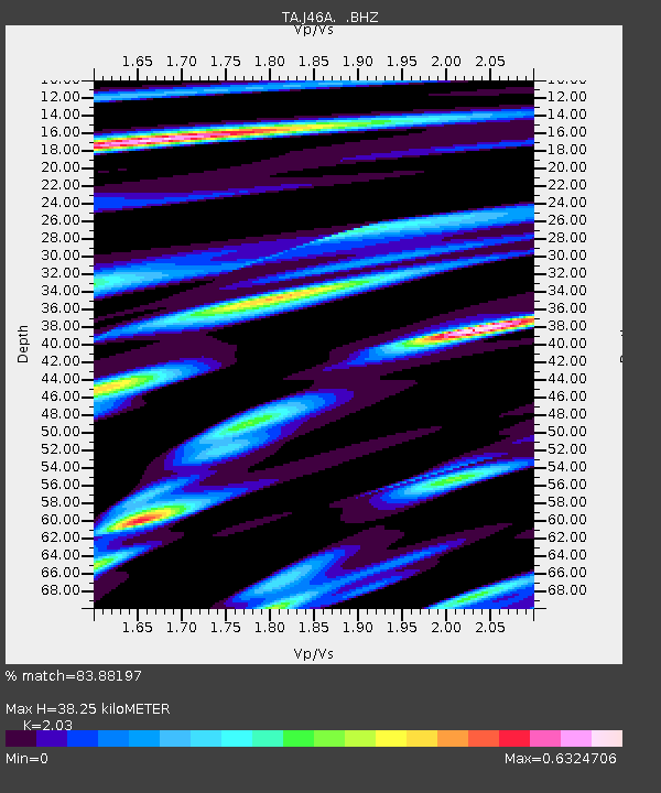
J46A Howard City, MI, USA - Earthquake Result Viewer
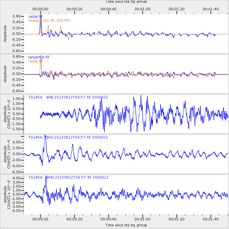
Earthquake location: Near Coast Of Northern Peru
Earthquake latitude/longitude: -5.4/-81.9
Earthquake time(UTC): 2013/08/12 (224) 09:49:32 GMT
Earthquake Depth: 10 km
Earthquake Magnitude: 6.2 MWW, 6.1 MWB, 6.2 MWW, 6.2 MWC, 6.3 MWC
Earthquake Catalog/Contributor: NEIC PDE/NEIC COMCAT
Network: TA USArray Transportable Network (new EarthScope stations)
Station: J46A Howard City, MI, USA
Lat/Lon: 43.35 N/85.65 W
Elevation: 275 m
Distance: 48.6 deg
Az: 356.384 deg
Baz: 175.063 deg
Ray Param: 0.069231905
Estimated Moho Depth: 38.25 km
Estimated Crust Vp/Vs: 2.03
Assumed Crust Vp: 6.483 km/s
Estimated Crust Vs: 3.193 km/s
Estimated Crust Poisson's Ratio: 0.34
Radial Match: 83.88197 %
Radial Bump: 400
Transverse Match: 67.04922 %
Transverse Bump: 400
SOD ConfigId: 626651
Insert Time: 2014-04-17 23:27:25.457 +0000
GWidth: 2.5
Max Bumps: 400
Tol: 0.001

Signal To Noise

ChannelStoNSTALTA
TA:J46A: :BHZ:20130812T09:57:45.300002Z7.9820322.778683E-63.4811723E-7
TA:J46A: :BHN:20130812T09:57:45.300002Z4.76096061.6016742E-63.3641828E-7
TA:J46A: :BHE:20130812T09:57:45.300002Z2.68818335.909445E-72.1983044E-7
Arrivals
Ps6.4 SECOND
PpPs17 SECOND
PsPs/PpSs23 SECOND