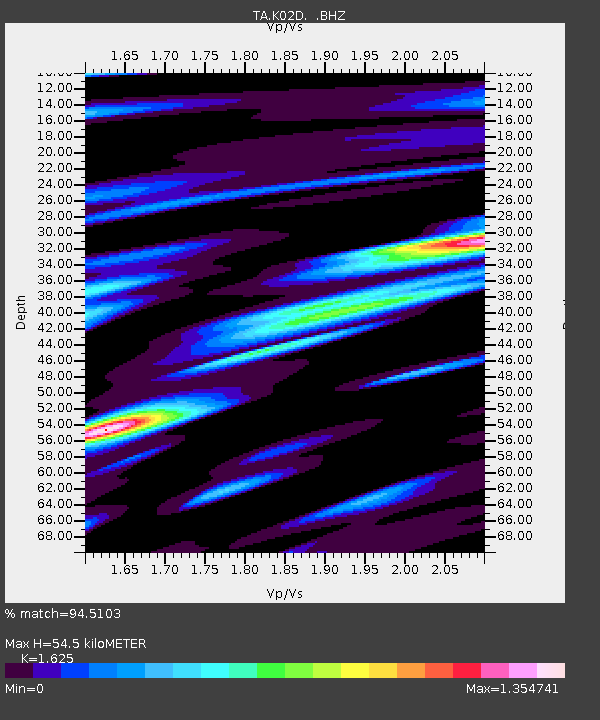
K02D Willamette Meridian, OR, USA - Earthquake Result Viewer
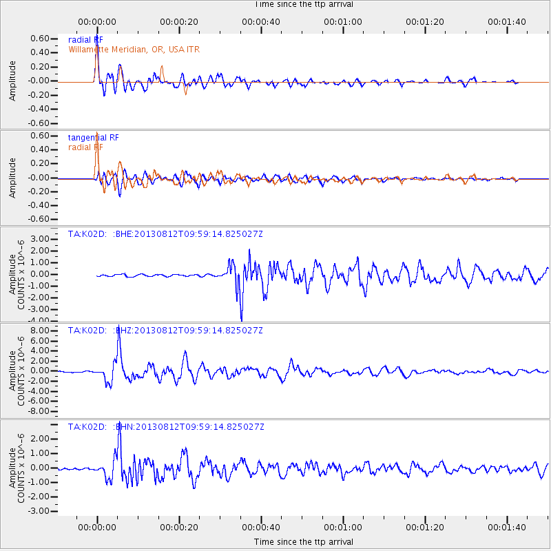
Earthquake location: Near Coast Of Northern Peru
Earthquake latitude/longitude: -5.4/-81.9
Earthquake time(UTC): 2013/08/12 (224) 09:49:32 GMT
Earthquake Depth: 10 km
Earthquake Magnitude: 6.2 MWW, 6.1 MWB, 6.2 MWW, 6.2 MWC, 6.3 MWC
Earthquake Catalog/Contributor: NEIC PDE/NEIC COMCAT
Network: TA USArray Transportable Network (new EarthScope stations)
Station: K02D Willamette Meridian, OR, USA
Lat/Lon: 42.70 N/123.67 W
Elevation: 989 m
Distance: 61.0 deg
Az: 325.869 deg
Baz: 130.735 deg
Ray Param: 0.06115148
Estimated Moho Depth: 54.5 km
Estimated Crust Vp/Vs: 1.62
Assumed Crust Vp: 6.522 km/s
Estimated Crust Vs: 4.013 km/s
Estimated Crust Poisson's Ratio: 0.20
Radial Match: 94.5103 %
Radial Bump: 400
Transverse Match: 88.02732 %
Transverse Bump: 400
SOD ConfigId: 626651
Insert Time: 2014-04-17 23:27:41.371 +0000
GWidth: 2.5
Max Bumps: 400
Tol: 0.001

Signal To Noise

ChannelStoNSTALTA
TA:K02D: :BHZ:20130812T09:59:14.825027Z16.026641.7188468E-61.07249356E-7
TA:K02D: :BHN:20130812T09:59:14.825027Z12.5886726.2775877E-74.986696E-8
TA:K02D: :BHE:20130812T09:59:14.825027Z9.4489787.8290043E-78.2855564E-8
Arrivals
Ps5.5 SECOND
PpPs21 SECOND
PsPs/PpSs26 SECOND