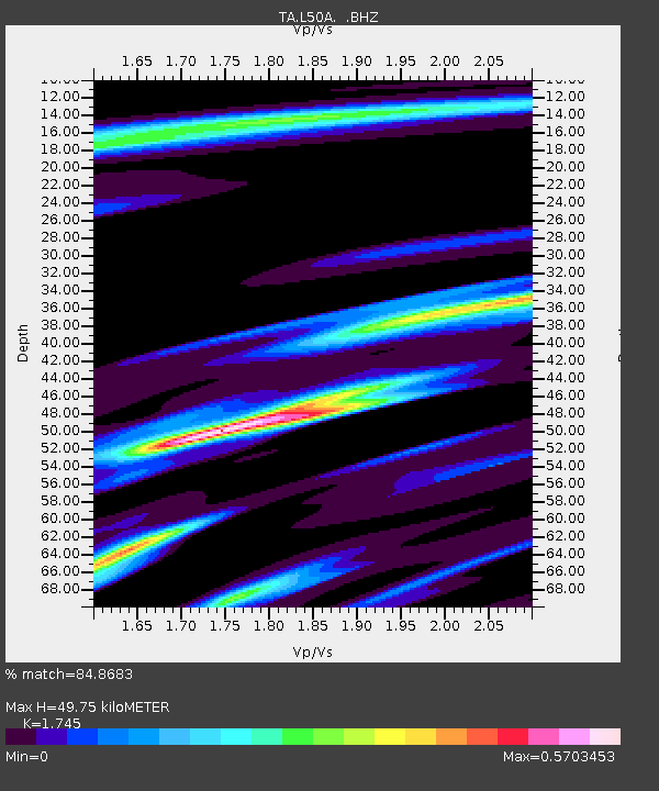
L50A Kingsville, ON, CAN - Earthquake Result Viewer

Earthquake location: Near Coast Of Northern Peru
Earthquake latitude/longitude: -5.4/-81.9
Earthquake time(UTC): 2013/08/12 (224) 09:49:32 GMT
Earthquake Depth: 10 km
Earthquake Magnitude: 6.2 MWW, 6.1 MWB, 6.2 MWW, 6.2 MWC, 6.3 MWC
Earthquake Catalog/Contributor: NEIC PDE/NEIC COMCAT
Network: TA USArray Transportable Network (new EarthScope stations)
Station: L50A Kingsville, ON, CAN
Lat/Lon: 42.04 N/82.81 W
Elevation: 187 m
Distance: 47.2 deg
Az: 359.104 deg
Baz: 178.803 deg
Ray Param: 0.07013582
Estimated Moho Depth: 49.75 km
Estimated Crust Vp/Vs: 1.75
Assumed Crust Vp: 6.483 km/s
Estimated Crust Vs: 3.715 km/s
Estimated Crust Poisson's Ratio: 0.26
Radial Match: 84.8683 %
Radial Bump: 259
Transverse Match: 61.724567 %
Transverse Bump: 364
SOD ConfigId: 626651
Insert Time: 2014-04-17 23:28:58.441 +0000
GWidth: 2.5
Max Bumps: 400
Tol: 0.001

Signal To Noise

ChannelStoNSTALTA
TA:L50A: :BHZ:20130812T09:57:34.374008Z8.0605312.774324E-63.4418628E-7
TA:L50A: :BHN:20130812T09:57:34.374008Z4.89824531.3137362E-62.6820547E-7
TA:L50A: :BHE:20130812T09:57:34.374008Z1.480522.3367102E-71.5783037E-7
Arrivals
Ps6.1 SECOND
PpPs20 SECOND
PsPs/PpSs26 SECOND