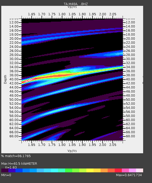
M48A Edgerton, OH, USA - Earthquake Result Viewer

Earthquake location: Near Coast Of Northern Peru
Earthquake latitude/longitude: -5.4/-81.9
Earthquake time(UTC): 2013/08/12 (224) 09:49:32 GMT
Earthquake Depth: 10 km
Earthquake Magnitude: 6.2 MWW, 6.1 MWB, 6.2 MWW, 6.2 MWC, 6.3 MWC
Earthquake Catalog/Contributor: NEIC PDE/NEIC COMCAT
Network: TA USArray Transportable Network (new EarthScope stations)
Station: M48A Edgerton, OH, USA
Lat/Lon: 41.48 N/84.72 W
Elevation: 258 m
Distance: 46.7 deg
Az: 357.12 deg
Baz: 176.183 deg
Ray Param: 0.070465595
Estimated Moho Depth: 40.5 km
Estimated Crust Vp/Vs: 1.63
Assumed Crust Vp: 6.498 km/s
Estimated Crust Vs: 3.986 km/s
Estimated Crust Poisson's Ratio: 0.20
Radial Match: 86.1765 %
Radial Bump: 261
Transverse Match: 71.83171 %
Transverse Bump: 400
SOD ConfigId: 626651
Insert Time: 2014-04-17 23:29:28.266 +0000
GWidth: 2.5
Max Bumps: 400
Tol: 0.001

Signal To Noise

ChannelStoNSTALTA
TA:M48A: :BHZ:20130812T09:57:30.525009Z8.377352.5265463E-63.0159256E-7
TA:M48A: :BHN:20130812T09:57:30.525009Z5.21250721.409296E-62.703682E-7
TA:M48A: :BHE:20130812T09:57:30.525009Z0.525282261.3414959E-72.5538574E-7
Arrivals
Ps4.2 SECOND
PpPs15 SECOND
PsPs/PpSs20 SECOND